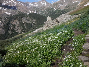
This route to the third highest peak in the lower 48 states takes the direct approach, and provides the shortest mileage route to the peak. From the lower trailhead to Mount Massive you continue driving up a rough, high clearance vehicle road for another 2+ miles to the well developed trailhead for Halfmoon Lakes. At this point you need to fill out a free permit registration to access the Wilderness Area. The hike starts out on the Halfmoon Lakes trail for about 1.5 miles, where you will then turn right on to the signed trial ascending to Mt. Massive. At this point the more moderate grade gives over to climbing. This short mileage approach is accomplished by simply having a route that runs overly steeply up the side of the mountain. Follow this route until you intersect the main trail up on the ridge, proceeding then on to the peak.
You may want to consider descending on the main trail, creating a loop hike of longer mileages but much gentler walking.
Mt. Massive is composed of a ridge system containing a number of sub peaks over 14,000'...and was once held out to be the better choice for Colorado's highest mountain. There were attempts to pile rocks up to augment the total height, hoping to beat out Mt. Elbert, but that up/down process finally ended with the concession that Mt. Elbert's 14,440' was the top of the state.
This is not an easy hike, but for any well conditioned hiker it is very doable. To avoid the overly steep class 2 climbing, simply hike to the peak using the lower trailhead. Both routes are very popular.
This hike is subject to the usual issues related to high elevations, and summer thunderstorms. Start early and enjoy the efforts.
WARNING! Hiking and outdoor related sports can be dangerous. Be responsible and prepare for the trip. Study the area you are entering and plan accordingly. Dress for the current and unexpected weather changes. Take plenty of water. Never go alone. Make an itinerary with your plan(s), route(s), destination(s) and expected return time. Give your itinerary to trusted family and/or friends.
Permit $$
Information is listed below
Directions
Road
High Clearance possible when dry
To hike From Leadville, follow 24 south to Rd 300, turning right and following for a bit over a mile, then turning left on Rd 11 (Halfmoon Lake Rd). Follow this road to the lower Mt Massive trailhead (past Halfmoon Lake/ Emerald Lake campgrounds)... then, proceed on up the posted high clearance vehicle road another 2+ miles to the well marked trailhead area for Halfmoon Lakes trail. Sign up for the free permit at the trailhead.
 Route Editor