 Route Editor

| Guide | ♦ | 8 Triplogs | 0 Topics |
details | drive | permit | forecast | route |
stats |
photos | triplogs | topics | location |
| 40 | 8 | 0 |
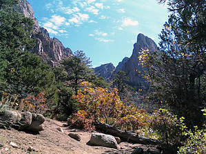
Hike Up Tram Down by Davis2001r6 Warning: Get an early start in Summer as temps can be 100. Conversely, the upper portion of the hike may be impassable in Winter due to Ice and Snow.
Hike: The trail leaves the parking lot and gradually climbs for 7.6 miles to the tram. After a half dozen sunny switchbacks the trail curves around into La Cueva Canyon. The Canyon is shaded in spots and switchbacks up into some treas, mostly ponderosa pines, blue spruce, and some aspens. Most choose to hike this one way and take the tram back down. There is a connector trail from the tram parking lot that can be taken to get back to your car which adds another 3 miles. They have made some improvements on the trail in recent years but you can still see the old trail in places, please follow the new trail and do not cut any switchbacks. All the intersections are well marked and there should be no problem following the trail. If you wish to go to the highpoint on the Sandia Mountains there is a turnoff near mile 6.5 to the Sandia Crest and Summit House, it's .5 miles one way to the crest on Spur Trail #84. From the Crest back to the tram it's 1.8 miles on Crest Trail #130. Water Sources: There is no water at the trailhead. The trail does cross a small stream, in La Cueva Canyon, it was not running when I was there and I would not count on it for water. Carry your own. Check out the Official Route and Triplogs. Leave No Trace and +Add a Triplog after your hike to support this local community. One-Way Notice This hike is listed as One-Way. When hiking several trails on a single "hike", log it with a generic name that describes the hike. Then link the trails traveled, check out the example. | |||||||||||||||||||||||||||||||||||||||||||||||||||||||||||||||||||||||||||||||||||||||||||||


