| Guide | ♦ | 8 Triplogs | 0 Topics |
details | drive | no permit | forecast | route |
stats |
photos | triplogs | topics | location |
| 57 | 8 | 0 |
Nice loop on Mount Tam by JimmyLyding Mount Tam has been referred to as the "Sleeping Lady." A Native American legend has a sun god kidnapping a maiden to live with him in the sky. However, the maiden fell and tripped over Mount Diablo in the East Bay. She landed at her final resting place which rose up to become a mountain that is supposedly in the shape of a sleeping woman.
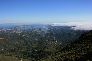
One of the more memorable periods of Mount Tam's history was when the infamous serial killer David Carpenter, AKA the "Trailside Strangler" brutally murdered a number of victims here from 1979 until 1981. This case is notable because it was one of the first instances of FBI profilers successfully using forensic evidence to apprehend a serial killer with the help of a psychological profile. We all owe a debt of gratitude to Agent John Douglas for helping to pioneer these valuable techniques. This hike, however, is lovely. The main parking area is across the Panoramic Highway from the Mountain Home Inn. The Inn seems to be a restaurant with splendid views where well-heeled folk drink fancy Chardonnay. Cross the highway immediately east of the Inn. The Gravity Car Grade trail branches to the right, a road to the Throckmorton Ridge Fire Station heads straight, and the Hogback trail follows that road on the left. Take the Hogback, and you will soon walk past the modern-looking fire station that features a roof covered in solar panels. The views from the Hogback trail are a taste of what is to come with panoramic vistas of the redwoods in Muir Woods National Monument below and San Francisco further south. Continue following the Hogback trail up the fairly steep grade to a water tower. There is a junction here, and you want to continue straight up a "fire road." This is basically a trail that is suitable for trucks to use when fighting wildfires. You will encounter 3-way junction about 1/4 mile up, and continue straight. Continue on about 0.2 miles to another junction where you'll want to go to the left up the Railroad Grade trail. A little more than a 1/4 mile later you will hit the Fern Creek trail. There will be a wooden bridge across Fern Creek. You can take the glorified game trail just before the bridge or cross the creek and take the official trail. The game trail is not recommended except for those who love ducking and scraping through manzanita thickets. The Fern Creek trail hits Ridgecrest Boulevard near its terminus just below East Peak. Take the paved path (it may be a road as it's in excellent condition, but looked too narrow for automobile traffic) up to the cluster of buildings just below the summit. There is a visitor center that sells everything from dry-mesh t-shirts to books about Mount Tam and a snack bar where you can buy a hot dog and a soda. You may encounter people who drove up here who might ask "did you hike up here?" We all love that. The final ascent to the summit is easy enough with only about 300 vertical feet. The first half of the 1/3 mile trail is on a wooden ramp. The summit features a fire lookout tower and expansive views of the Sonoma Valley, the extensive mountains and ridges to the north, the redwoods and San Francisco to the south, and most of the Bay Area. The skylines of San Francisco and Oakland are easily identified. You will see the marine layer (fog) gently enveloping the seaward side of the Golden Gate, the Peninsula, and nearby Marin Coast if you're lucky. Head back down the summit the way you came to near the snack bar, and take the Verna Dunshee trail around the north side of the mountain. The drainage to the west frequently features turkey vultures soaring over the deep forest below. You can also take a trail straight down the west side of the peak to the snack bar though the lower end is somewhat closed even the upper end is open. There is also a route along the south side of the peak that leads to a developed trailside lookout before both it and the Verna Dunshee trail connect with the Temelpa trail. Temelpa gently switchbacks down the east side of East Peak until its junction with the Vic Haun trail to the right (south). Take the Vic Haun trail as it follows the contour near the head of Cascade Creek until it meets the Railroad Grade trail/fire road. Take the Railroad Grade/fire road for about 1/10 mile and then jump on the Hoo Koo E Koo trail until it rejoins the Hogback trail a short ways above the water tower you saw just past the fire station. The previous 1.5 mile along the Vic Haun and Hoo Koo E Koo trails is absolutely gorgeous as you wind through thick chaparral in the portions on the ridgesides and forests of younger redwoods, California bay laurel, and Douglas fir in the drainages. Make your way back the way you came from the water tower, and enjoy a glass of fine Chardonnay at the Mountain House Inn. Check out the Official Route and Triplogs. Leave No Trace and +Add a Triplog after your hike to support this local community. | |||||||||||||||||||||||||||||||||||||||||||||||||||||||||||||||||||||||||||||||||||||||||||||||||
 Route Editor


