Route Editor

| Guide | ♦ | 1 Triplog | 0 Topics |
details | drive | no permit | forecast | route |
stats |
photos | triplog | topics | location |
| 47 | 1 | 0 |
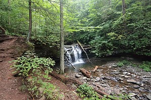
Lollipops are Deeeelicious ! by gpsjoe At the outbreak of the American Civil War in 1861, Robert Bruce Ricketts enlisted as a private in the U. S. Army. Fighting for the Grand Army of the Potomac, Ricketts led Battery F during the Battle of Gettysburg. Ricketts swiftly moved up in the ranks and when the war ended, was discharged a colonel.
Fishermen exploring the lower reaches of Kitchen creek (around 1868) discovered waterfalls. Exploration revealed that two branches of Kitchen Creek cut through gorges in a series of waterfalls that united at Waters Meet and followed through a glen among giant pines, hemlocks and oaks. Col. Ricketts built trails to the area of the waterfalls, which came to be known as the Glens Natural Area. Ricketts named individual waterfalls after American Indian tribes. Ricketts also named waterfalls for his family and friends. The lower glen came to be called Ricketts Glen. Many of the magnificent trees in this area are over 300 years old. Diameters of almost four feet are common and trees tower to 100 feet in height. The area is the meeting ground of the southern and northern hardwood types, creating an extensive variety of trees. The Glens became a registered National Natural Landmark in 1969, and in 1993 became a State Natural Area and will be protected and maintained in a natural state. (End of lifted text). The hike is a 7.2 mile lollipop that is designed to go by the 21 named waterfalls. There are use trails that go to the base of each waterfall for great photos and dramatic effect. That will make your total trip more like 8 miles or so before the day is done. Going in you hike the stem of the lollipop for 1.5 miles of easy hiking before reaching the first waterfall. There is a signed fork before the first waterfall for an Upper Moderate trail (should really say easy) and a Lower Difficult trail (should say moderate). They reconnect right at the first waterfall. The lower trail closely follows the water and I preferred that but did both (one in and one out) which is also a choice. The trailhead is at 1,300 feet and the high point is slightly over 2,300 feet. Water tumbles down 1,000 feet in about 1.5 mile while creating the waterfalls. At the end of the day you accumulated elevation gain will be about 1,300 feet. These are all very moderate numbers. Rocks can be slippery when wet and those slightly underwater can be very slippery as I found out the hard way. At "Waters Meet" you can go left or right and it probably does not matter. After a few waterfalls on the right fork there is a signed short cut trail. Don't take it or you will miss a couple of neat waterfalls. Stay right if you are hiking counter clockwise. Turn left on the Highland trail at the sign to cross over to the other fork and go down that one to pass the remaining waterfalls. A short distance past the top of the loop is Lake Jean and the PA State Ricketts Glen Park Office. Near there are 120 structured campsites each with a picnic table. There are also cabins for rent there that can be booked online at www.visitPAparks.com. If a conventional hotel is you preference then choose either Wilkes-Barre (40 miles away) or Bloomsburg (30 miles away) since there are no closer accommodations. This is a wonderful 5 star hike. If you are a 2 hour or less drive from this area then do it by all means. If you will be near that are for other reasons or can pair this up with other adventures nearby then also go for it. You will be greatly rewarded. It is very popular so after Labor Day or before the summer in May on a week day would be best to minimize the number of hikers on the trails. Check out the Official Route and Triplog. Leave No Trace and +Add a Triplog after your hike to support this local community. | |||||||||||||||||||||||||||||||||||||||||||||||||||||||||||||||||||||||||||||||||||||||||