Route Editor

| Guide | ♦ | 7 Triplogs | 1 Topic |
details | drive | permit | forecast | 🔥 route |
stats |
photos | triplogs | topic | location |
| 55 | 7 | 1 |
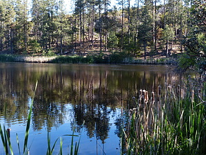
Surprising Lake in the Pines by AZWanderingBear   Overview OverviewThe southern Bradshaw Mountains are pretty dry. So finding an alpine lake here is surprising. A nice little trail loops around the lake. Warning Horsethief Road from Crown King to Horsethief Lake is not routinely maintained. Four-wheel drive is not required, but some clearance is.
In the 1930s the CCC did extensive work in this area of the Bradshaw Mountains. Besides the construction of Hazlett Hollow and Turney Campgrounds, they also constructed an arch dam and created Horsethief Lake. Hike After arriving at the lake, park and proceed north. The path takes you over the rock and cement spillway which keeps the lake from flowing over the dam. You will need to clamber up about 3 feet to get onto the top of the dam. The arched dam provides a nice walkway and views across the small lake. At the far end of the dam, look back to admire the construction and how high the dam rises. The trail continues along the edge of the lake. Cattails and other reeds line the lake's edges, but a few clear places are used by anglers. Bass and bluegills are the predominant fish in the lake. Occasionally visitors may find a fisherman in a small boat casting peacefully. Only electric motors or paddling is allowed. Various duck species make the lake home. Often you will see mothers and babies patrolling the edges of the lake, sometimes even approaching for a handout. Expect to find numerous animal tracks in the sand and mud near the lake. It is a reliable water source. You might even notice the grasses and tender aquatic plants along the lake edge have been grazed down by deer. A sandbar on the northwestern edge of the lake is a favorite bedding ground for spawning. Look closely in the shallow water for activity. The trail continues around and deposits you back at your start point. Bring your camera and a fishing pole. Water Sources Potable water is available from Spring to Autumn at the Ranger Guard Station and Hazlett Hollow and Turney Campgrounds nearby. Camping Extensive dispersed camping opportunities, as well as Hazlett Hollow Campground, are nearby. Check out the Official Route and Triplogs. Leave No Trace and +Add a Triplog after your hike to support this local community. | ||||||||||||||||||||||||||||||||||||||||||||||||||||||||||||||||||||||||||||||||||||||||||||