 Route Editor

| Guide | 0 Triplogs | 0 Topics |
details | drive | no permit | forecast | map |
stats |
photos | triplogs | topics | location |
| 10 | 0 | 0 |
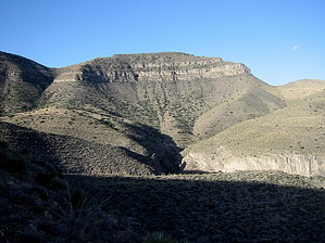
Great to be there...not to get there! by imike There is no trail, from bottom or top. The logical approach is to drive up to Forest Road 90A, the Long Ridge forest road that accesses the radio towers above the formation off of West Side Road. If you choose this option, you will have to park at the locked gate at the intersection of 90a and 93. Park and walk the 2.5 miles to the end of the road past the tower arrays. At this point, the depressing news. While you can clearly look out and see the ridge leading out to the formation, unfortunately the route is blocked by an overly thick bushwhack... dwarf oaks and assorted scrub. The temptation is to head off in a beeline. That is the route I used, in reverse (I climbed up from the valley, ending the hike up on the road). Instead, I have to believe that it would be better to head north over to the edge of the ridgeline over the Alamo Canyon drainage, and follow that ridge above Deadman Canyon, connecting finally to the end of the ridge that provides the route on out and back up to the Steamboat. While the one way route lists only a 200' AEG, the out and back will pick up an additional 1400' from the ups and downs and reclimbing the hill back to the road.
All the effort will be nicely rewarded once you are out past the forest and moving more easily on the Steamboat. Enjoy the effort and great views you're about to capture. An alternative approach: from Alamogordo, hike up into Alamo Canyon and follow one of the Deadman Canyon drainages up and onto an approach ridge... and do the overly steep hike/climb on up to the ridge. It will take not much more time than the long drive, and will offer a much greater reward. Plan on a long day; take lots of water. Take care and prepare for emergencies. The downclimb could be harder than the ascent. So... enjoy the day, one way or another scoring this great highpoint formation. Gate Policy: If a gate is closed upon arrival, leave it closed after you go through. If it is open, leave it open. Leaving a closed gate open may put cattle in danger. Closing an open gate may cut them off from water. Please be respectful, leave gates as found. The exception is signage on the gate directing you otherwise. Leave No Trace and +Add a Triplog after your hike to support this local community. One-Way Notice This hike is listed as One-Way. When hiking several trails on a single "hike", log it with a generic name that describes the hike. Then link the trails traveled, check out the example. | ||||||||||||||||||||||||||||||||||||||||||||||||||||||||||||||||||||||||||||||||||||||||||


