 Route Editor

| Guide | ♦ | 3 Triplogs | 0 Topics |
details | drive | no permit | forecast | route |
stats |
photos | triplogs | topics | location |
| 12 | 3 | 0 |
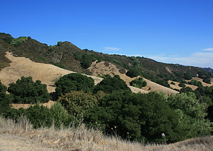
Accipiter City by JimmyLyding  Las Trampas is a small slice of the scrubby mountain range lying between metropolitan Oakland to the west and the suburban cities along I-680 to the east. The area is the classic California mixture of evergreen woodland and grassland. Among the trees found here are interior live oak, blue oak, valley oak, and the occasional Pacific madrone. The grassland areas are known for abundant wildflowers in the spring. Deer and coyotes are frequently seen here, and feral hogs also inhabit the area. The most noticeable wildlife are the raptors, however. Cooper's, sharp shinned, and red tailed hawks dot the sky along with turkey vultures.
The hike begins at the staging area at the northern end of Bollinger Canyon Road. The trailhead is located at the northeast corner of the staging area back across the bridge over the creek that you drove over to get to the large parking lot. Maps are available at the staging area. The first portion of the hike follows Bollinger Creek up the canyon to its head. The trail goes a few yards outside of the short oak gallery forest that lines the creek left of the trail. There are numerous side trails going down to the creek, and countless bubble trails that leave the main track only to rejoin it a short distance later. The canyon rises above you to the right towards Las Trampas Ridge. There are numerous small canyons spilling down towards the trail from the top of the ridge, and are marked by dense dark-green oak forests that stand in contrast to the golden grassy hillsides. These grassy hillsides are gold-colored in summer and fall but strikingly green in the winter and spring. You reach the saddle dividing the Bollinger Creek and Las Trampas Creek canyons after about 1.5 miles, and the views are already magnificent. There is a fork at the saddle, and you turn right to reach Las Trampas Peak. This trail quickly ascends the west slope of Las Trampas Ridge until you reach another fork .22 mile up from the saddle junction. Go right to take a footpath to the top of the ridge or stay left on the fire road you've been traveling on. The trails meet again .22 mile if you go left and .38 mile if you go right. From here it is .53 mile to the summit on the Las Trampas Ridge trail featuring a .25 mile, 200-foot-deep descent into a saddle just south of the final ascent to the peak. Las Trampas Peak is at the northern end of mile-long Las Trampas Ridge, and there are views in every direction. San Francisco Bay and Rocky Ridge are to the west. Visible to the north are cities of Moraga, Orinda, Lafayette, Walnut Creek in addition to the industrial facilities along Suisun Bay. The sizeable suburbs of Livermore and Dublin are in front of the Diablo Range to the south. Mount Diablo dominates the view to the east. The peak is relatively open with a few large oaks interspersed amongst the windy grassland. There is a small stock tank just below the peak to the north along a route that can be taken to reach both Alamo and Moraga. To return you should retrace your path back down the ridge to the southeast on the Las Trampas Ridge trail for 1.72 miles until you head down the Chamise Trail. There are areas of dense chaparral interspersed with dense oak forests and grasslands that give a beautiful foreground to long-distance views in all directions. Chamise follows along the top of the ridge down the east side of Bollinger Creek Canyon. There are fine views of the tributary canyons that flow into Bollinger Creek. Chamise trail's .57 mile route takes you back to the bottom of Bollinger Creek Canyon, and you turn right at the bottom of the switchbacks to take the Bollinger Creek Loop trail 1/3 mile back to the staging area. Check out the Official Route and Triplogs. Leave No Trace and +Add a Triplog after your hike to support this local community. One-Way Notice This hike is listed as One-Way. When hiking several trails on a single "hike", log it with a generic name that describes the hike. Then link the trails traveled, check out the example. | |||||||||||||||||||||||||||||||||||||||||||||||||||||||||||||||||||||||||||||||||||||


