Canyons are inherently risky. Flash floods occur without notice on sunny days. Technical skills & surrounding topography knowledge required yet does not eliminate risk. |
|
tap row or icons for details
|
| Difficulty |
|
4 of 5 |
| Route Finding |
|
2 of 5 |
| Distance One Way |
|
2 miles |
| Trailhead Elevation |
|
4,762 feet |
| Elevation Gain |
|
1,500 feet |
| Accumulated Gain |
|
1,540 feet |
| Avg Time One Way |
|
3 hours |
| Kokopelli Seeds |
|
7.13 |
| Interest Off-Trail Hiking, Seasonal Waterfall & Seasonal Creek | | Backpack No | | unreported if dogs are allowed
editedit > ops > dogs to adjust |
| | |
|
|
6 |
2015-02-26 |
|
|
|
19 |
2015-02-24 |
Deadman - Rock Spring Ridge |
imike |
|
|
|
28 |
2010-10-05 | imike |
|
| |
|
|
| |
|
|
Historical Weather |
| Trailhead Forecast | | |
|
 |
|
|
| Preferred Apr, Mar, Oct, Nov → Early |
|
|
|
Seasons Early Autumn to Early Spring |
|
|
| | |
| |
Named Locations Coordinate Links
| |
|
| help future canyoneers |
| post a gps route now |
| | |
| |
|
|
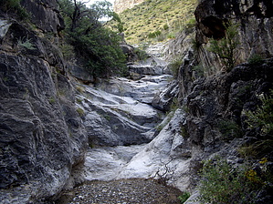
It's the Stops that Kill Ya! by imike   The South Fork section of Deadman Canyon fortunately includes that really nice 1.5 miles of pleasant canyon bottom hiking, shared with the North Fork. Once they split, the characteristics are nothing alike. Where the North Fork remained nicely open and ambling, the South Fork closes in immediately. Right after the first turn you are blocked off by a 25' overhanging waterfall... that can be traversed very steeply around to the right. This pattern continues as you are blocked by various falls and chutes. Through this section my GPS unit recorded me as taking nearly an hour of downtime, yet I never stopped for a break! Climbing the falls was interpreted to be standing still. It does not take long to make you way up and out of the steeply cut drainages, into the broad basin that comprises the north side of the mountain below the Steamboat formation. The drainages fan out, but if you need a destination, head up to Steamboat Caverns (more like Steamboat Cave-In) at the base of the cliffs below the formation. There is no safe, easy or good route all the way to the top from this area. If you want to peak out, move further to your left (east) around into the next major drainage valley (Middle Fork) and work your way up through the cliffs to the ridge. From there it is an easy hike on up to the top of the Steamboat formation. If you are not using this canyon to access the Steamboat, the better end to this hike is to not go all the way up to the Cave, but to hike east and north across the adjacent drainages, heading for the Roundup Grounds. The terrain allows for relatively easy movement and if you are really lucky you will slide around the hills coming out over in the far North Fork drainage just above the large waterfall. From there it is not far on over and around to the Roundup Trail. Or, enjoy your downclimb back in the South Fork drainage. While none of the falls really comprised a technical climb coming up, you may want to have 80' of rope along to facilitate lowering your pack (and self?) down the cuts.
I'd describe the setting in the South Fork cut to be intimate. It is fairly closed in, though not to the extent of a slot canyon. You can reasonably expect to have the canyon if not the whole drainage to yourself. |
 Route Editor