|
tap row or icons for details
|
| Difficulty |
|
0.5 of 5 |
| Route Finding |
|
1 of 5 |
| Distance One Way |
|
0.8 miles |
| Trailhead Elevation |
|
5,083 feet |
| Elevation Gain |
|
42 feet |
| Accumulated Gain |
|
109 feet |
| Avg Time One Way |
|
1 hour |
| Kokopelli Seeds |
|
1.16 |
| Interest Perennial Creek | |
| | |
|
|
12 |
2021-06-25 |
|
|
|
22 |
2021-05-05 |
Watson Lake Loop |
jillyonanadventu |
|
|
|
9 |
2017-11-25 |
Flume Trail - Watson Lake |
DbleDutch |
|
|
|
4 |
2016-05-28 | joebartels |
|
|
31 |
2016-04-16 |
Constellation Willow Watson Lake Loop |
rayhuston |
|
|
|
19 |
2016-04-16 |
Constellation Willow-Watson Loop |
The_Eagle |
|
|
|
20 |
2015-10-07 |
|
|
|
15 |
2015-08-01 |
|
| | Page 1, 2 |
| |
|
|
|
list |
map |
done |
Prescott Region |
| | |
|
| |
|
|
Historical Weather |
| Trailhead Forecast | | |
|
 |
|
|
| Preferred Apr, Oct, Nov, Mar |
|
|
| | |
| |
Named Locations Coordinate Links
| |
|
| Dam Trail - Watson Lake
|
1.69 mi
252 ft |
|
|
| Dam Trail - Watson Lake
|
0.82 mi
109 ft |
|
|
|
Watson Lake Loop
| 2021-05-05 |
jillyonanadventure |
|
6.57 mi
622 ft |
 |
| Storm Ranch Loop & WPs
|
6.82 mi
856 ft |
|
|
| Constellation Willow-Watson Loop
|
16.19 mi
1,756 ft |
|
|
| Watson Lake Loop
|
5.66 mi
681 ft |
|
|
| Northshore Trail - Watson Lake
|
6.7 mi
640 ft |
|
|
| | |
| |
|
|
Overview
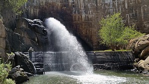
From the Trailhead off East Granite Dells road, this trail takes you to the Watson Lake Dam. Also access to Over-The Hill and Peavine trails. Use this Trailhead also to access the Flume Trail.
One-Way NoticeThis hike is listed as One-Way. When hiking several trails on a single "hike", log it with a generic name that describes the hike. Then link the trails traveled, check out the example. |
 Route Editor


