username
X
password
register
for free!
help
 This is likely a great time to hike this trail!  Check out "Preferred" months below, keep in mind this is an estimate.
  

Watson Lake Loop, AZ

Guide 62 Triplogs  0 Topics
  3.7 of 5  
Fav
Wish
6
details
drive
permit
forecast
route  
stats
photos
triplogs
topics
location
615 62 0
Statistics
tap row or icons for details
Difficulty 2 of 5
Route Finding 2 of 5
Distance Loop 5.05 miles
Trailhead Elevation 5,251 feet
Elevation Gain -170 feet
Accumulated Gain 550 feet
Avg Time Round Trip 2-4 hours
Kokopelli Seeds 7.8
feature photo
Photos Viewed All MineFollowing
Will recalculate on button tap!
16  2025-07-18 ddgrunning
69  2025-05-19
Tis Elementary
DesertNymph
23  2023-08-26 DarthStiller
8  2023-06-16 Tortoise_Hiker
4  2022-10-21
Peavine Tr and Watson Lake
GrangerGuy
16  2022-08-13
Peavine National Recreation Trail
kingsnake
15  2021-11-24 Tortoise_Hiker
4  2021-09-21 tdwood
Page 1,  2,  3,  4,  5
Author
author avatar Guides 16,843
Routes 17,472
Photos 24
Trips 1 map ( 6 miles )
Age 28 Male Gender
Location HAZ, TrailDEX
Associated Areas
list map done
Prescott Region
Historical Weather
Trailhead Forecast
Radar Map
Expand Map
Preferred Oct, Apr, May, Sep
Sun  6:05am - 6:51pm
Official Route & 7 Rts
 
8 Alternative


 Likely In-Season!
Overview
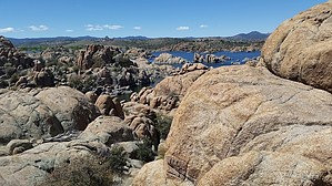
This hike starts from the southern boat ramp (canoe/Kayak rental area) within Watson Lake Park. It more or less follows the lakeshore.


Use the GPS route provided here for the best results. The north end might be a challenge to follow without using the GPS route. It's pretty easy to find with the GPS route.
remove free decal offer
Resourceful hikers can figure out how to start from other locations.

2015-01-01 HAZ_Hikebot


    Check out the Official Route and Triplogs.
    Leave No Trace and +Add a Triplog after your hike to support this local community.
    WARNING! Hiking and outdoor related sports can be dangerous. Be responsible and prepare for the trip. Study the area you are entering and plan accordingly. Dress for the current and unexpected weather changes. Take plenty of water. Never go alone. Make an itinerary with your plan(s), route(s), destination(s) and expected return time. Give your itinerary to trusted family and/or friends.

     Permit $$
    Special Use

    Special
    Summer Hours: (Memorial day-Labor day) 6:00 AM - 10:00 PM, Winter Hours: 7:00 AM - Sunset, $3.00 parking fee


     Directions
    or
     Road


    To hike
    From Prescott, AZ-69 go North on AZ-89 for 3.4 miles. Turn right at the traffic circle into Watson Lake Park. Follow the signs to the Canoe and Kayak rental area. Right on East Granite Dells road. 0.2 mile to TH on the right.
    page created by The_Eagle on Oct 10 2010 8:53 pm
     90+° 8am - 6pm kills
    helpcorrectionissue

    end of page marker