Route Editor

| Guide | ♦ | 7 Triplogs | 0 Topics |
details | drive | no permit | forecast | map |
stats |
photos | triplogs | topics | location |
| 35 | 7 | 0 |
Canyons are inherently risky. Flash floods occur without notice on sunny days. Technical skills & surrounding topography knowledge required yet does not eliminate risk.
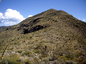
Horse Ride without the Gee! by imike  If you are hiking from the bottom, you have to choose which feeder ridge to hike up. It does not really matter, but there has been a pattern of use on the ridge that begins a bit further up and into Beeman Canyon. If you choose not to head up the obvious longer ridge on your left, then hike up the wash or old jeep track (they both end up the same place) and once in site of the secondary ridge, make your move to the left. If you're lucky (?) you might spot some old cairns or ribbons posted by some horse riders. For some very odd reason they marked this ridge route for quite aways up... even once on the ridge.
If you are hiking up the ridge, you may want to consider looping back down the North Spur... and enjoying the pleasant hiking and down climbing through the Jumble in Beeman Canyon. If you continue on up past the meadow, you will be walking the jeep road. Probably will not be too many vehicles, but they are possible. The noise you hear is the boom of guns... the most popular target practice range is off Hiway 82 in Dry Canyon, below you to the North. The real way to enjoy Horse Ridge is to down hike it, using it as the second half of a loop after coming up Beeman Ridge, Beeman Canyon (any of the 3 routes)or any route that takes in Winter Peak. Mileage and elevation for your hike will be determined by just how far up you go. The plants and rocks along the ridge are all sharp and prickly. Nice to have gloves along. As with all off trail environments, most of the rocks are not stable. Walk carefully out there! You can drive closer into the mouth of Beeman Canyon, but I prefer to leave my car out along the Scenic Drive Blvd, parking in the church parking lot or at the Maze. Use your own judgement...the gravel track off of Scenic (behind the church) is rough... and the chances for vandalism have to be greater back in there. Check out the Triplogs. Leave No Trace and +Add a Triplog after your canyon trip to support this local community. | |||||||||||||||||||||||||||||||||||||||||||||||||||||||||||||||||||||||||||||||||||||||||||