Route Editor

| Guide | ♦ | 13 Triplogs | 4 Topics |
details | drive | permit | forecast | route |
stats |
photos | triplogs | topics | location |
| 711 | 13 | 4 |
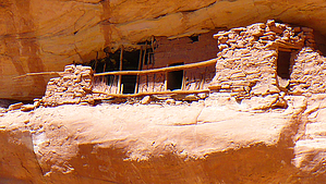
Backpack to Ruins and Rock Art by strawlady Basics: I did this as a 3.5 day/3 night backpack and it could easily take longer with more exploring for ruins and rock art, or taken at a more leisurely pace. Register at the Kane Ranger station or you can make reservations with the Monticello Field Office as noted below in the permit section. I recommend you purchase a topo map of Grand Gulch at the Ranger station ($12 cash only) or carry a good guide book, since none of the ruins are marked or signed. Drive around to Hwy 276 milepost 85 to the dirt road that leads to the Collins Spring trailhead. (It was 6 miles and okay for low clearance, as long as you took the slickrock sections really carefully. It may be worse if it has rained recently).
I left the confluence at 7 am and reached Polly's about 1 pm, hiking at a steady B pace. In another 1.5 miles, you pass the amazing Big Man Panel of rock art. It is high on the right side of the canyon, just past a sharp turn. Again, there are no signs, so keep your eyes out and look for the side trail that heads up a steep slope. No touching - there are video cameras at most of the major ruins and art to make sure nobody disturbs them. There is another unnamed ruin along the trail past Big Man Panel, with a well-worn side trail to it. The willow is pretty thick by now, so this isn't the most fun hiking and camping spots are few and far between, but the treasures along the way make it worth it. Cow Tank Canyon is another 2 miles past Big Man Panel. I reached there about 4:30 pm and found a nice camping area. On Day 3, I left my tent and day-hiked up to Step Canyon. There is an amazing ruin right at the entrance to this side canyon and it can be reached with a little care on the slickrock ledge. I explored up this canyon a little, but it was mostly a waste of time and a lot of bushwacking through thick willow. In another mile, I reached the rock formation known as Totem Pole, which was as far as time would allow that day. The willow is thick up to here, but I understand it thins out past Totem Pole and there are many more ruins and rock art beyond Totem, if you can do a trip where you exit Bullet Canyon. I plan to return and approach the area from Bullet Canyon on another trip. I glimpsed three people on the four days I was in Grand Gulch and spoke to one man who had come in the Government trail and was having trouble finding the Big Man Panel. Mostly, I only heard birds and it was delightful. I hiked back from Totem, picked up my backpack at Cow Tank and took it to Polly's Canyon on Day 3 where I camped comfortably on the slick rock. Day 4, I hiked out and saw more little ruins that I had missed on the way in, which is a reason to go in and out the same way. Summary: It was tiring - muddy river, sandy trails and thick willow - but it was an intimate glimpse into Anasazi life. Some of the trails are deep trenches, that show they have been trod for hundreds or thousands of years. And this is only a beginning to what that area has to offer. I'm hooked! Check out the Official Route and Triplogs. Note This is a moderately difficult hike. Leave No Trace and +Add a Triplog after your hike to support this local community. | |||||||||||||||||||||||||||||||||||||||||||||||||||||||||||||||||||||||||||||||||||||