 Route Editor

| Guide | ♦ | 15 Triplogs | 0 Topics |
details | drive | no permit | forecast | map |
stats |
photos | triplogs | topics | location |
| 59 | 15 | 0 |
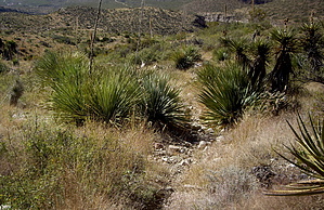
If You Can Find It, Go For It! by imike  Unfortunately, finding this little used trail is not entirely easy.
Leaving 426, crossing the drainage and ascending the hill immediately south of the drainage, you work your way up and around the obvious rocky outcropping above you to the east. Head around to the south side (right side) and you will finally pick up a very clearly worn track. From this point on you should have no problem following the worn but slightly over grown path. Your views down into the canyon to your left will be dramatic. The trail climbs steadily, winding up and back towards Ortega Peak. You will eventually encounter some large cairns with a track coming in from your left. That is the upper terminus of Mineral Springs trail (not shown to go that far south on the Map, but it does, and makes a great loop hike when combined with Lost Trail). From the intersection the trail winds south and east, climbing up and around, finally connecting with an old Jeep route that heads left over into Dry Canyon, or to your right to connect with T119 and Ortega Peak. The intersection is effectively the end of Lost Trail. If you venture further with the intent of returning by this same route, make careful note of what the trail looks like at that intersection; it can be very easy to overlook coming from either direction on the old Jeep track (Dry Canyon-Ortega Traverse). This route gives a very nice mid basin connection, opening up the options for a variety of trail and off trail loops, including some very nice drainage hikes. Take the time to find this lost gem. Check out the Triplogs. Leave No Trace and +Add a Triplog after your hike to support this local community. One-Way Notice This hike is listed as One-Way. When hiking several trails on a single "hike", log it with a generic name that describes the hike. Then link the trails traveled, check out the example. | ||||||||||||||||||||||||||||||||||||||||||||||||||||||||||||||||||||||||||||||||||||||||||


