Route Editor

| Guide | ♦ | 46 Triplogs | 0 Topics |
details | drive | no permit | forecast | route |
stats |
photos | triplogs | topics | location |
| 392 | 46 | 0 |
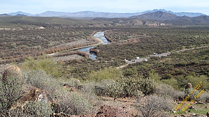
Avoid the Crowds & U Will Njoy by sventre  Coon Bluff can become a bustling location, especially during the hot summer months. However, the area provides an opportunity for some terrific views, year-round flowing water, and other treats as close as one can get to the city. This loop hike can be either a simple matter of "exercise," or it can prove to be filled with enchantment. Everything is in the timing. Coon Bluff can become a bustling location, especially during the hot summer months. However, the area provides an opportunity for some terrific views, year-round flowing water, and other treats as close as one can get to the city. This loop hike can be either a simple matter of "exercise," or it can prove to be filled with enchantment. Everything is in the timing.Getting to the trailhead is simple enough. From the west, take Power Road past the Granite Reef Dam and along Bush Highway until you see the turnoff for Coon Bluff Rd. From the east, travel along Bush Highway about 1 mile past the intersection with Usery Pass Road. Once on Coon Bluff Road, proceed about 0.4 miles to the parking area on your left. The trailhead is at the far southwest corner of the parking area (33.54400N, 111.63541W).
The Hike Almost immediately after you leave the trailhead, you will begin a steep but short climb up to the ridge that crests the hills leading north to Coon Bluff. Water runoff erodes the hillside trail, but it is easy to find with only moderate difficulty maintaining one's footing. Once atop the ridge, it is a fairly flat trek across to the bluff. Now is the time to enjoy a sunrise, the sounds of the river, and an encounter with the Wild Stallions if you are fortunate. On earlier hikes, I have come within inches of these beautiful creatures, but this day I saw the band of stallions across the intervening valley and upon a hillside to the west. They were engaged in grazing and "horseplay" in the early sunlight. The trail continues to the Bluff itself, and from here, you can descend to the east for a visit to one section of the Lower Salt River Recreation area. You will notice that by parking at the trailhead, you have avoided paying the recreational area fee. The route described here does not include descending to the river but instead proceeds to the northwest along a game trail that terminates just shy of an unnamed wash, which separates Coon Bluff from a plateau that overlooks the Phon D. Sutton Recreation Area. Pick your way down the steep walls of the wash (33.54570N, 111.65165W) and then head south a short distance through the wash until you locate a viable location for climbing out the western wall. [I've rated the hike a 2.5 difficulty only because of this wash crossing, else it is a 1.] From here, you will bushwhack up and across the plateau, maintaining a closeness to the northern edges for better views of the river. There is an abundance of game trails to assist you, and eventually, your west-by-northwest trek will cross an abandoned jeep trail. Follow along the jeep trail to the northwesternmost edge of the small plateau and what appears to be a gravesite marked with a tall vertical "headstone." From this point, you will descend toward the flat ground, which abuts the entry drive to the recreation site. Make your own path back toward the trailhead by selecting among the numerous washes, game trails, and horse tracks covering the area. Check out the Official Route and Triplogs. Leave No Trace and +Add a Triplog after your hike to support this local community. | ||||||||||||||||||||||||||||||||||||||||||||||||||||||||||||||||||||||||||||||||||||||||||||