Route Editor

| Guide | ♦ | 17 Triplogs | 0 Topics |
details | drive | no permit | forecast | map |
stats |
photos | triplogs | topics | location |
| 173 | 17 | 0 |
Canyons are inherently risky. Flash floods occur without notice on sunny days. Technical skills & surrounding topography knowledge required yet does not eliminate risk.
Rockbound! by imike  To hike Ortega Canyon it is easiest to park at the bottom of the drainage by the city water storage tank off of Thunder Road. This is the same point to begin the Lost Canyon drainage hike. It is also possible to simply park at the Trailhead for "A" trail (T119) and walk over to the drainage (.3 miles), or park to the north off of Indian Wells Road, walking up Little Mineral Springs trail and traversing over to the mouth of the canyon, adding a couple of miles to the hike. Depending on how you intend to create your return loop will determine the best place to begin your hike.
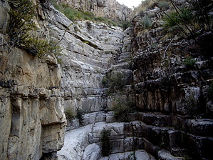
Starting out, take careful note on the map (GPS route is even better) to make sure you follow the correct drainage cut; there are a number of offshooting side drainages. You could easily end up in Lost Trail South if you follow the wrong route. You want to move east in the cut closest to the ridge with all of the homes. The houses will sit on the ridge immediately to your right for the first mile or so up into the canyon. The canyon forks around the 5200' level... you want to follow the left hand fork to the north. This canyon is a delight for the first 2.5 miles of your hike. Bedrock inclines, small bouldering, great rock formations. It is not high drama but it just stays pleasing. It caps that experience with a great 40' slotted staircase waterfall. I think just about anyone would enjoy this canyon through that point. The canyon winds and climbs , splitting again around the 6,000' level... both forks carrying you to just below the 7,000' level, exiting onto the broad grassy foothills below Ortega Peak. Unfortunately, both forks cliffs out at waterfalls within .1 mile of their split, the north fork falls looking very much like an old rounded bandstand. There is a 20' vertical wall of rotten rock, then the floor of the bandstand. For most hikers, this is the end of the hike. You could loop up and over on the left up through an iffy fault, but if you really want to continue up, it is likely smarter to drop back and down, around into the south split, moving up towards it's overgrown terminus. Do not bother to push your way all the way up to the falls... it just is not worth the effort. Instead, keep looking to your left and pick a spot to make your way up through the rock cliffs, topping onto the bench between the two forks. Then, move back to the north working your way above the bandstand. I chose a narrow chimney crack that provided very secure footing and handholds, about 20 yards before the terminus... but it is a vertical ascent of around 15'. This point and some others above require more extensive bouldering and minor climbing. Do not attempt unless you are comfortable with those efforts. That north side cut makes its way all the way up to the Ortega/Dry Canyon Traverse. You do not have to exit the drainage to top out. You will walk up and out right below Ortega Peak. In fact, you could follow the drainage up and onto the peak. The return looping options include heading south over to "A" trail (T119), heading north for Lost Trail, or north for Mineral Springs trail. All of those options assume you continued uphill until you intersect the Ortega Peak/Dry Canyon Traverse, the old jeep track on the west side of Ortega Peak. This one is worth the effort, at least for that initial 2.5 miles. You just gotta climb that slot falls! Check out the Triplogs. Leave No Trace and +Add a Triplog after your canyon trip to support this local community. | |||||||||||||||||||||||||||||||||||||||||||||||||||||||||||||||||||||||||||||||||||||||||||