 Route Editor

| Guide | ♦ | 20 Triplogs | 1 Topic |
details | drive | no permit | forecast | map |
stats |
photos | triplogs | topic | location |
| 48 | 20 | 1 |
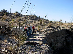
It's a Rock Garden! by imike The hike begins with a steep walkup to the Wall through the Maze. Once on top, the path follows the edge of the Wall in and out and around the outward ridge curves between the drainage cuts. These serpentine protrusions create ten little mini-plateaus that provide close to 4 miles of interesting hiking. During the initial 1.5 miles there is an old jeep track running along generally following the ridgeline up. In fact, you can begin the hike a little further north, connecting with that jeep track for an easier walk up the hill. But, this hike is the Garden Wall... if you leave the ridge edges you'll be hiking in the Garden... don't. The nicer views and nicer path is out along the wall top.
The drainage at the end of the Garden Wall coincides with Beeman Canyon South on the far side of the ridge. It would be possible to climb up the drainage, cross the ridge, then hike down that rough canyon and loop around and down Beeman Canyon... or follow Beeman Ridge back to the Basin. Additionally, you could cross Beeman Canyon, climbing up to Horse Ridge to enjoy that path back down and around. On its own, the Garden Wall is more of a picnic hike. This off trail route invites a nice morning of easier walking with Basin and City views. Check out the Triplogs. Leave No Trace and +Add a Triplog after your hike to support this local community. One-Way Notice This hike is listed as One-Way. When hiking several trails on a single "hike", log it with a generic name that describes the hike. Then link the trails traveled, check out the example. | ||||||||||||||||||||||||||||||||||||||||||||||||||||||||||||||||||||||||||||||||||||||||||


