Route Editor

| Guide | ♦ | 6 Triplogs | 0 Topics |
details | drive | no permit | forecast | route |
stats |
photos | triplogs | topics | location |
| 11 | 6 | 0 |
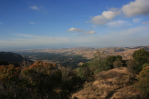
Hike to Mount Diablo summit from the north side by JimmyLyding  Mount Diablo is possibly the San Francisco Bay Area's most visible landform. It is reputed that the view from the summit shows more of the earth's surface than any place on earth other than Mount Kiliminjaro. I wouldn't go that far, but the view is expansive. The summit area now houses a visitor's center, but its importance goes far beyond that. In 1851 Leander Ransom led the team that began to map most of California and Nevada using base- and meridian lines with Mount Diablo's summit as the starting point. These measurements are still used today.
Take the Back Creek trail to the right, and the trail heads almost due west through an open grassland before dropping into the Back Creek drainage. The trail gently ascends along the drainage through a riparian forest of various oak species, California buckeye, and walnut. The canyon bottom is densely thicketed, and relatively open areas of chaparral and grassland provide open views above. The Back Creek trail continues its mellow ascent up the drainage for about 2 miles before a few very steep and exposed sections provide one with a nice cardio workout. The junction with the Tick Wood trail on the east side of Back Creek is a rough boundary between the easy and difficult portion of the Back Creek trail. Continue along the trail to Back Creek's headwaters, and the trail turns almost due east after about 3 miles from the trailhead. The trail then turns due south soon before meeting a 5-way junction. Take the Bald Ridge/Eagle Peak trail to the southeast and be amazed by the views in all directions. Here you'll get a taste of the expansive views from the summit. The Bald Ridge trail travels along the top of the ridge for about a mile until it reaches Prospector's Gap and another 5-way junction. Go right (south) on the North Peak trail, and you will soon turn west just below the Mount Diablo summit. The trail intersects the summit road before continuing on to the actual summit after a sharp switchback to the east. There are a visitor's center, bathrooms, parking lot, and lots of people who may think you're crazy for having hiked up here instead of driving. There are numerous options for the return trip. However, I'll save those write-ups for future adventures. Check out the Official Route and Triplogs. Leave No Trace and +Add a Triplog after your hike to support this local community. | ||||||||||||||||||||||||||||||||||||||||||||||||||||||||||||||||||||||||||||||||||