Route Editor

| Guide | ♦ | 15 Triplogs | 0 Topics |
details | drive | no permit | forecast | map |
stats |
photos | triplogs | topics | location |
| 81 | 15 | 0 |
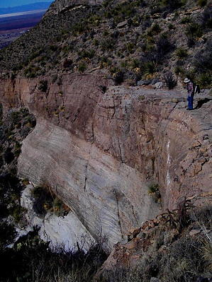
Canyons are inherently risky. Flash floods occur without notice on sunny days. Technical skills & surrounding topography knowledge required yet does not eliminate risk.
High Hopes! by imike  I guess it is a good thing to have our expectations knocked down now and again.
I did note that looping down through it's sister canyon, Lost Trail Canyon, North, that I was once again enjoying that pleasant mix of rock, plants and views in a balance that restored my day. That seemed to be missing over in the south fork. The hike begins right in town at the city water tank. Dropping into the drainage you walk the first rocky, gravelly mile past the houses on the adjoining ridge to your right. You pass the cut on your right up into Ortega Canyon (...now, that's a nice canyon!) and move up to the slick rock waterfall coming in on your left. This is the real beginning of the South Fork. Up and over the waterfall would carry you up the North Fork. Instead, you turn right and follow the scrubby drainage east. At about 1.5 miles into the hike you will come to a fork. The minor canyon to your left is too overgrown to enjoy going too far up into, but there is a nice breakfast rock shelf about 50 yds up canyon if you want to check it out. Your real path is to the right. Around 2.5 miles into the hike, the canyon splits once again. The left fork cliffs out shortly after the fork, but it does include a series of nice rock slab shelving to check out. The main canyon moves to the right up a series of boulders and small falls... still overgrown. There is a touch of interesting climbing/scrambling to top out the falls there. Finally, around 3 miles into the hike, once again the canyon splits with the right fork again providing the better route to the top. This time you will work your way up and around a blocked off dirt/gravel spill over (easy on the left) then confront a 60' cliffed out falls. You can scramble up the right side, or take the more challenging slot cut on the left side; or some combination thereof? The hike is about over at this point. As you move off above the falls, angle to the left (north) and finally exit the bottom and climb up the low ridge to your left, intersecting the Dry Canyon/Ortega Traverse trail. From this point you have a very easy and much nicer hike down to Lost Trail, following it to Lost Trail Canyon: North Fork... which you can follow down and right back to your car. Or... follow the Traverse trail south to connect with T119, following that steep route down. It will take you to within .3 mile of where you parked. So... it was nice enough to do again, but no time soon. Enough time needs to pass to forget that it is not really all it could/should be. If I had hiked this one before I'd discovered all those other... nicer... canyons...?? Oh, well... High Hopes. Check out the Triplogs. Leave No Trace and +Add a Triplog after your canyon trip to support this local community. | ||||||||||||||||||||||||||||||||||||||||||||||||||||||||||||||||||||||||||||||||||||||||||||||