username
X
password
register
for free!
help
  🔥

Crucifix Canyon, AZ

Guide 27 Triplogs  0 Topics
  3.7 of 5  
Fav
Wish
6
details
drive
no permit
forecast
🔥
route  
stats
photos
triplogs
topics
location
385 27 0
Statistics
tap row or icons for details
Difficulty 3 of 5
Route Finding 3 of 5
Distance Shuttle 5.5 miles
Trailhead Elevation 2,610 feet
Elevation Gain 540 feet
Accumulated Gain 540 feet
Avg Time Hiking 5 hours
Kokopelli Seeds 7.3
 Interest Off-Trail Hiking & Seasonal Creek
 Backpack Yes
 Dogs not allowed
feature photo
Photos Viewed All MineFollowing
Will recalculate on button tap!
22  2025-02-05
Superstition Reds
DixieFlyer
15  2025-01-11 BiFrost
9  2025-01-08 fdv75
20  2024-12-05
Crucifix Canyon to the Bat Cave
The_Eagle
20  2024-12-05
Crucifix Canyon to the Bat Cave
wallyfrack
8  2024-02-17 fdv75
13  2023-12-19 adilling
10  2023-05-09 ScottHika
Page 1,  2,  3
Author
author avatar Guides 1
Routes 1
Photos 10
Trips 1 map ( 5 miles )
Age 81 Male Gender
Location Cottonwood, AZ
Associated Areas
list map done
Phoenix Region
Historical Weather
Trailhead Forecast
Radar Map
Expand Map
Preferred Feb, Jan, Dec, Nov → 8 AM
Seasons   Autumn to Spring
Sun  6:01am - 6:47pm
Official Route & 8 Rts
 
4 Alternative
 
Historic Fire Perimetersacres
🔥 2024 Siphon Fire35.9 mi*
🔥 2019 Woodbury Fire123.8k
🔥 View (All) - over Official Route 🔥
*perimeter length in miles


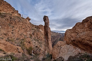
Stark remote craggy and challenging
by Hardboater

Route with waypoints

This is a route in the traditional Grand Canyon sense although perhaps not as strenuous. The 5.5-mile route starts at the head of the canyon from FS 80 with a scant footpath dropping into the canyon. Once into it, there are craggy rocks and steep cliffs all along the beautiful remote canyon. It gets deeper as the route approaches Canyon Lake. There is a guano cave above the canyon floor to the north at 33 33.67N 111 23.69W. A bit further west is a choke rock requiring technical climbing down and more importantly up! So access to Canyon Lake is problematic, ie without technical gear ascending the choked section back up and out does not appear possible to this non-climber author. Backtrack to 33 33.602 N, 111 23.565 W for the exit to the south which is a scramble up a 560 ft elevation gain. Pick up an old ridgeline road going south that gently descends. Once a perennial stream and water impoundment are located, ford across above the water impoundment structure. Your shoe tops won't get wet fording this creek. Pick up another old road once across heading generally southeast. To get to the cars, ford Mesquite Creek where your shoe tops might get wet.


The stark and remote beauty of this canyon makes it a worthwhile hike. Bushwhacking and boulder hopping are necessary to both avoid causal water and circumnavigate boulder piles. The climb out is a bit arduous so it's not for the casual hiker. GPS, long pants, sturdy boots, and gloves are recommended. Anyone injured will have a difficult time getting out or summoning help as there is limited satellite accessibility and certainly a helicopter rescue is not possible in the canyon itself.
remove free decal offer
Two cautionary notes 1) Investigating the guano caves means getting it on your shoes, ankles, and higher up one body. Perspiration makes the guano stick and stink! It is an unpleasant odor to both yourself and your hiking companions. Stripping and bathing in Mesquite Creek might be mandated by your hiking companions especially the owners of the shuttle cars. 2) The choke rock is a significant vertical drop and a non-technical climber might not be able to retrace their route out. Consider this obstacle carefully before descending this rock.

2010-11-13 Hardboater


    Check out the Official Route and Triplogs.
    Leave No Trace and +Add a Triplog after your hike to support this local community.
    WARNING! Hiking and outdoor related sports can be dangerous. Be responsible and prepare for the trip. Study the area you are entering and plan accordingly. Dress for the current and unexpected weather changes. Take plenty of water. Never go alone. Make an itinerary with your plan(s), route(s), destination(s) and expected return time. Give your itinerary to trusted family and/or friends.

     Permit $$
    None


     Directions
    or
     Road
    FR / Dirt Road / Gravel - Car Okay

    To hike
    This is a point-to-point hike as described although out and back is possible. Take AZ 88, Apache trail from Mesa past Tortilla Flats to Mesquite Flats. Leave a shuttle car as well as many cars as possible at Mesquite Flats. There is limited parking at the trailhead. Continue on AZ 88 to FS 80. Take it back to the gated section for TNFS personnel only. There is limited parking in the area. The scant footpath starts to the northwest of the parking area. There is no marker.
    page created by Hardboater on Nov 13 2010 2:54 am
     90+° 8am - 6pm kills
    helpcorrectionissue

    end of page marker