username
X
password
register
for free!
help


Big Canyon to LCR Gorge, AZ

Guide 9 Triplogs  2 Topics
  5 of 5  
Fav
Wish
9
details
drive
permit
forecast
map
stats
photos
triplogs
topics
location
225 9 2
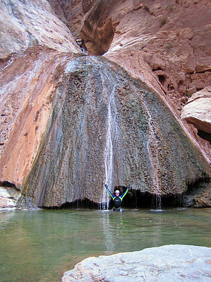
Canyons are inherently risky. Flash floods occur without notice on sunny days. Technical skills & surrounding topography knowledge required yet does not eliminate risk.
Canyoneering
Consensus
View 2
Grade3
WaterB
Risk
TimeIV
Statistics
tap row or icons for details
Distance One Way 12 miles
Trailhead Elevation 5,245 feet
Accumulated Gain 3,200 feet
Kokopelli Seeds 22.66
 Interest Off-Trail Hiking, Perennial Waterfall & Perennial Creek
unreported if dogs are allowed
editedit > ops > dogs to adjust
feature photo
Photos Viewed All MineFollowing
23  2013-05-25
Salt Trail Canyon to LCR Gorge
AZOutdoorsman
35  2012-04-28 azmike
99  2012-03-11 suzaz
61  2010-11-14 Vaporman
7  2010-11-14 toddak
Author
author avatar Guides 16,843
Routes 17,472
Photos 24
Trips 1 map ( 6 miles )
Age 28 Male Gender
Location HAZ, TrailDEX
Historical Weather
Trailhead Forecast
Expand Map
Preferred Apr, May, Oct, Nov
Sun  6:00am - 6:50pm
1 Route
 
0 Alternative


remove free decal offer

  
Overview
Rugged & remote route to an amazing oasis in the desert thru the technical lower narrows of Big Canyon before it drops into the Little Colorado River Gorge and hike out the Salt Trail Canyon back up to your vehicle


2019-11-21 HAZ_Hikebot


    Check out the Triplogs.
    Leave No Trace and +Add a Triplog after your canyon trip to support this local community.
    WARNING! Hiking and outdoor related sports can be dangerous. Be responsible and prepare for the trip. Study the area you are entering and plan accordingly. Dress for the current and unexpected weather changes. Take plenty of water. Never go alone. Make an itinerary with your plan(s), route(s), destination(s) and expected return time. Give your itinerary to trusted family and/or friends.

     Permit $$
    Navajo Nation Reservation
    Navajo Permits & Services
    navajonationparks.org


     Directions
    or
     Road
    High Clearance possible when dry

    To canyon trip
    Drive to the Salt Trail Canyon TH and then hike cross country to the steep descent canyon marked as 'trailhead'.
    page created by Vaporman on Nov 15 2010 7:08 pm
     90+° 8am - 6pm kills
    helpcorrectionissue

    end of page marker