 Route Editor

| Guide | ♦ | 23 Triplogs | 0 Topics |
details | drive | no permit | forecast | 🔥 route |
stats |
photos | triplogs | topics | location |
| 169 | 23 | 0 |
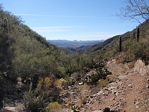
Winding Around the Hills by MEWhiteman  Overview OverviewThis section of the Black Canyon Trail (BCT) begins at Soap Creek Road in Black Canyon City where the K-Mine North Section finishes and goes north for 7.2 miles to a trailhead on Crown King Road in Bumble Bee. It is a nice hike amount hills and valleys on the south end and with nice views of the Bradshaws and Crown King on the north half. You'll cross the gas pipeline a couple of times, some washes/small rivers, and a couple of dirt roads. Most of the trail is single track. Vegetation is varied and plentiful. Information on the Black Canyon Trail can be found at www.bctaz.com although at the time I hiked this section, there was no information on this particular section. Hike This can be done from either end. There is more parking at the north end but as I only knew where the south end was when I started, this description is in the northbound direction. Leaving from the trailhead at N34 05.440 W112 09.381 you head down off the road and circle around a deep wash. The trail tends to follow the contours of the hills as opposed to going up and down them. At 0.6 miles (N34 05.673 W112 09.531) you come to a gate. The trail continues to wind around with lots of switchbacks when climbing until coming at 1.9 miles to a major tributary to the Agua Fria River called Black Canyon Creek on my map. The trail on the south side is at N34 06.204 W112 09.344 (for those hiking south). The trail on the north side is direct across at N34 06.204 W112 09.344. At 2.1 miles (N34 06.637 W112 09.378) turn left off two-track and at 2.2 miles (N34 06.334 W112 09.364) go through a second gate. Shortly at N34 06.340 W112 09.356 join a two-track and at 2.5 miles (N34 06.637 W112 09.378) turn left off two-track. Shortly (N34 06.637 W112 09.389) pass through the third gate. Now begins the longest climb on the hike following a drainage up to a saddle.
This is a nice hike which can be done as an out & back or as a one way by spotting a car at your endpoint. It can also be combined with other sections of the BCT for a longer hike. Gate Policy: If a gate is closed upon arrival, leave it closed after you go through. If it is open, leave it open. Leaving a closed gate open may put cattle in danger. Closing an open gate may cut them off from water. Please be respectful, leave gates as found. The exception is signage on the gate directing you otherwise. Check out the Official Route and Triplogs. Leave No Trace and +Add a Triplog after your hike to support this local community. One-Way Notice This hike is listed as One-Way. When hiking several trails on a single "hike", log it with a generic name that describes the hike. Then link the trails traveled, check out the example. | ||||||||||||||||||||||||||||||||||||||||||||||||||||||||||||||||||||||||||||||||||||||||||||||||||||||||||||||||||||||||||||||||||||||||||||||||||||||||||||||||||||||||||||||||||||||||||||||||


