 Route Editor

| Guide | ♦ | 24 Triplogs | 0 Topics |
details | drive | no permit | forecast | 🔥 route |
stats |
photos | triplogs | topics | location |
| 311 | 24 | 0 |
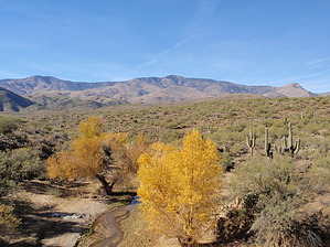
Bumble Bee Valley by MEWhiteman  Overview OverviewThe Black Canyon Trail is recognized as a National Recreational Trail and at the time I am writing this (December 2010), it is a work in progress. Information on history and trail work events can be found at www.bctaz.com. At this time the BCT website only provides information on the trail and trailheads as far north as Soap Springs Rd. Information on other sections will be added to Hike Arizona as I or others explore them. This section of trail is recently constructed/maintained and is mostly single-track. It appears it previously followed Crown King Rd as there are a couple of markers there, but the single track is much nicer for hiking. There are great views of the Bradshaws. As you near Bumble Bee you are hiking through the valley below the Sunset Point rest stop on I-17.
The hike can be done in either direction, but I have done it from south to north as I knew where to start at the south end but not the north end when I began the hike. From the south end, the trail north begins across Crown King Rd from the trailhead. (From the parking at the north end, the trail can be found by a short easy bushwack following a wash NNW from the parking, passing a spring as you go.) The trail is easy to follow along the contours of the hills and washes as you travel north. At about 2.2 miles you cross the gas pipeline where the trail is marked with large cairns. At 3.46 miles (N34 10.944 W112 09.722) you cross a dirt road (not Crown King Rd). Continue across the road. Shortly you begin to see Bumble Bee in the distance ahead of you. The Sunset Point rest area can be seen on the ridge to your right and is recognized by the towers. The trail bears left at about 4.0 miles (N34 11.442 W112 09.728) and comes to Crown King Rd at 4.19 miles (N34 11.399 W112 09.815) just across from the 4 Mile marker. The Black Canyon Trail goes right from here but there were no signs indicating that when we hiked it. At about 4.37 miles you cross a bridge over Bumble Bee Creek and the Black Canyon Trail turns left off the road at a marked turn shortly thereafter (N34 11.551 W112 09.724). At the time we hiked this the creek was flowing and the cottonwoods were a golden color. The trail follows a double track for a short distance then makes another marked left down and through a wash. You come to a gate at 4.7 miles (N34 11.689 W112 09.756). The trail bears to the right after the gate and follows a single track. You'll see the north end of the trail parking on your right at about 4.9 miles and will cross a wash at about 5.0 miles. This is as far as we hiked this day as we needed to return to the start. You can follow the wash to get to the parking if your car is there. The one-way distance is 5.0 miles. The AEG northbound is about 525' and southbound about 580'. Gate Policy: If a gate is closed upon arrival, leave it closed after you go through. If it is open, leave it open. Leaving a closed gate open may put cattle in danger. Closing an open gate may cut them off from water. Please be respectful, leave gates as found. The exception is signage on the gate directing you otherwise. Check out the Official Route and Triplogs. Leave No Trace and +Add a Triplog after your hike to support this local community. One-Way Notice This hike is listed as One-Way. When hiking several trails on a single "hike", log it with a generic name that describes the hike. Then link the trails traveled, check out the example. | ||||||||||||||||||||||||||||||||||||||||||||||||||||||||||||||||||||||||||||||||||||||||||||||||||||||||||||||||||||||||||||||||||||||||||||||||||||||||||||||||||||||||||||||||||||||||||||||||


