 Route Editor

| Guide | ♦ | 21 Triplogs | 0 Topics |
details | drive | no permit | forecast | 🔥 route |
stats |
photos | triplogs | topics | location |
| 235 | 21 | 0 |
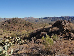
Ups and Downs by MEWhiteman   Overview OverviewThe Black Canyon Trail is a historic trail which when completed, will run from Carefree Highway in Phoenix to Williams. This section runs from just south of Bumble Bee to Government Spring on Crown King Road at the junction with Yavapai County 179. It gradually climbs to its high point over 3 miles and then follows the terrain's ups and downs to its endpoint. It is easy hiking on a newly maintained trail (as of Dec 2010) and provides many distant views of the Bradshaws, the Mazatzals, and areas between. There are numerous mines in the area, with the largest being the Hidden Treasure Mine near the north end. Hike From the south trailhead, it is a short easy bushwack to the trail. I placed a cairn at the north side of the parking area, indicating a clear area to walk down into a wash. Cross this wash. I placed another cairn at a pile of rocks (N34 11.838 W112 09.674) where there is a spring. Walk along the right side of this small wash that ends at the spring. In a short distance, you'll be able to cross the small wash to the left and reach the trail. You can pick up the trail anywhere along the west side of the small wash, so you don't have to be too precise. Pick the easiest path.
If you go left on the dirt road, reached at 6.08 miles, it will take you to the Hidden Treasure Mine. There are two large holes here, so don't get too close, but it is an interesting place to explore. Northeast of the mine itself appears to be some ruins of water collection and containment constructions. Again, more to explore. This ends this segment. We did it as an out & back, but you can do it one-way or as a leg of a longer hike. It was a nice hike! Check out the Official Route and Triplogs. Leave No Trace and +Add a Triplog after your hike to support this local community. One-Way Notice This hike is listed as One-Way. When hiking several trails on a single "hike", log it with a generic name that describes the hike. Then link the trails traveled, check out the example. | |||||||||||||||||||||||||||||||||||||||||||||||||||||||||||||||||||||||||||||||||||||||||||||||||||||||||||||||||||||||||||||||||||||||||||||||||||||||||||||||||||||||||||||||||||||||||||||||||||


