Lake Tahoe, known to many as "Big Blue" is split in two by California and Nevada. The name has been traced back to the Washoe Indians who used a phrase "Da ow ga", which translates to "the lake". Tahoe came about after listening to the Indian enunciation of this phrase. In 1850 California became a state and about that time a search party entered this area trying to help stranded emigrants. John Bigler was one of that party. He later became Governor of California. Somehow his name became attached to this body of water and it wasn't until 1945 when the California legislature finally made the name determination of Lake Tahoe for this body of water.
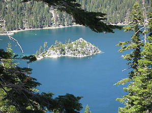
At the southwest corner of this lake lies the Desolation Wilderness. With its forests, 130 beautiful lakes and sporting three of the tallest granite peaks surrounding the Tahoe basin this is the most heavily used wilderness in the country. The Eagle falls loop gives most people the opportunity, albeit short, to experience panoramic views of Lake Tahoe and Emerald Bay which is home to the only island on Lake Tahoe, Fannette, from a wilderness setting.
The Eagle falls loop trail starts on a raised wooden sidewalk to protect wetlands from a paved parking lot which has restroom facilities and picnic benches. The trail, which is well groomed, can be completed by most people who can climb stairs and is child and dog friendly. Take the loop in either direction and enjoy the placards along the way and occasional bench to catch your breath. The spring time is especially nice with a healthy flow of water in Eagle creek from the snow melt. The granite mountains around you have been sculpted by ancient glaciers and are monumental. At about the one third mile mark there is a side trail marked to a photo vista, not to be missed. The trail now takes you closer to the rumbling creek and 58 foot upper Eagle falls. In the distance you can see a wooden bridge crossing the creek, which is your turn around point. Travel beyond the bridge requires a wilderness permit, even for day hikes. These permits are available at the trailhead at no cost. Your return part of the loop is down stairs with great views of the Lake Tahoe Basin.
WARNING! Hiking and outdoor related sports can be dangerous. Be responsible and prepare for the trip. Study the area you are entering and plan accordingly. Dress for the current and unexpected weather changes. Take plenty of water. Never go alone. Make an itinerary with your plan(s), route(s), destination(s) and expected return time. Give your itinerary to trusted family and/or friends.
Permit $$
Special Use
Special $7.00 exact change required
Directions
Road
Paved - Car Okay
To Eagle Falls Trailhead Along Highway 89, 8.5 miles northwest of Highway 50 junction at South Lake Tahoe. Park at the trailhead on the south side of the highway for a fee. If you are lucky, you can get a free parking spot along the road near the trailhead, but most areas are posted "No Parking".
From Phoenix 749 mi – about 12 hours 39 mins
From Los Angeles (I-5 & I-10) 493 mi - about 7 hours 49 mins From Sacramento (I-5 & I 80) 116 mi - about 2 hours 15 mins From Lone Pine (Whitney & US 395) 244 mi - about 4 hours 52 mins
 Route Editor