 Route Editor

| Guide | ♦ | 15 Triplogs | 0 Topics |
details | drive | no permit | forecast | route |
stats |
photos | triplogs | topics | location |
| 59 | 15 | 0 |
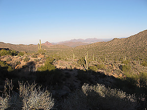
Avoid the Fees and Crowds by sventre  This is a relatively easy early morning or sunset hike with splendid views of both the East Valley and Lower Salt River. It can be done in either direction or as an out-n-back hike. You will need a shuttle if you decide to do it one-way. Park one vehicle at the Meridian TH and the other at the unnamed trailhead along Usery Pass Rd. This is a relatively easy early morning or sunset hike with splendid views of both the East Valley and Lower Salt River. It can be done in either direction or as an out-n-back hike. You will need a shuttle if you decide to do it one-way. Park one vehicle at the Meridian TH and the other at the unnamed trailhead along Usery Pass Rd.The hike is entirely along the trails connecting both of the trailheads; and, predominantly along the "better" portions of the Pass Mountain Trail. As you climb up the face of Pass Mountain views of the lower valleys continue to expand and you will see Fountain Hills, Blue Point Bridge, Stewart Dam, Four Peaks, as well as the Bull Dog Canyon. Personally, I find the southerly portions of Pass Mountain Trail somewhat unspectacular and often filled with mountain bikers, and joggers. This hike avoids much of that as well as the parking fees for Usery Park. Instead, your time spent hiking capitalizes on the views that develop along the northerly bounds of the peak itself.
This morning's hike was cool and we enjoyed the peaceful quiet (apparently, the activity at the shooting range was down to a minimum). My daughter and one of the grand pups accompanied me; and, perhaps that added to the overall enjoyment. The trailheads are close enough to East Valley towns to be readily accessible for those with only a few hours available for exercise. Check out the Official Route and Triplogs. Leave No Trace and +Add a Triplog after your hike to support this local community. One-Way Notice This hike is listed as One-Way. When hiking several trails on a single "hike", log it with a generic name that describes the hike. Then link the trails traveled, check out the example. | ||||||||||||||||||||||||||||||||||||||||||||||||||||||||||||||||||||||||||||||||||


