 Route Editor

| Guide | ♦ | 2 Triplogs | 0 Topics |
details | drive | no permit | forecast | map |
stats |
photos | triplogs | topics | location |
| 15 | 2 | 0 |
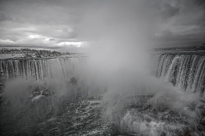
 The Trail was built and is maintained by earnings from The Niagara Parks Commission, a self-funded agency of the Ontario Government. Niagara Parks is dedicated to preserving and enhancing the beauty of the lands adjacent to the Niagara River for the enjoyment of its visitors. Check out the Triplogs. Leave No Trace and +Add a Triplog after your hike to support this local community. One-Way Notice This hike is listed as One-Way. When hiking several trails on a single "hike", log it with a generic name that describes the hike. Then link the trails traveled, check out the example. | ||||||||||||||||||||||||||||||||||||||||||||||||||||||||||


