 Route Editor

| Guide | ♦ | 31 Triplogs | 0 Topics |
details | drive | no permit | forecast | route |
stats |
photos | triplogs | topics | location |
| 147 | 31 | 0 |
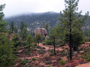
Payson's backyard by PrestonSands   Overview OverviewThe Cypress Trail takes one through the eroded granite formations of Payson's Granite Dells and is a part of the Payson Area Trails System or "P.A.T.S.". One can hike the Cypress Trail by itself, or create a 5 or 7-mile lasso-loop hike by connecting with the Boulders Loop Trail. One can also access the mid-point of the Cypress Trail at the Phoenix Street trailhead for a shorter hike. Pay close attention to the P.A.T.S. trail signs to avoid taking a wrong turn onto one of the area's numerous ATV paths. The following description begins at the north trailhead on Granite Dells Road. Hike From the trailhead on Granite Dells Road, follow the Cypress Trail south past a large brown signboard with a crude map of the area's trails. The Cypress Trail winds along the eastern base of Yerba Senta Butte at first, along sandy slopes of eroded granite. There are some nice views across Stewart Pocket, with the Gibson Peak rim forming the backdrop. Pinyon pine, juniper, and scrub oak dominate the area, with scattered ponderosa pines adding welcome shade. The route bends west and then south, roller-coasting over several small washes and low outcrops of granite boulders.
At a little over 2 miles from its start (and just under a mile past the Phoenix Street spur trail), the Cypress Trail meets the Boulders Loop Trail at a nice little forested flat next to the creek. Return the way you came, or create a lasso-loop hike by turning onto the Boulders Loop Trail.
Check out the Official Route and Triplogs. Leave No Trace and +Add a Triplog after your hike to support this local community. One-Way Notice This hike is listed as One-Way. When hiking several trails on a single "hike", log it with a generic name that describes the hike. Then link the trails traveled, check out the example. | |||||||||||||||||||||||||||||||||||||||||||||||||||||||||||||||||||||||||||||||||||||||||||||||||||||||||||||||||||||||||||||||||||||||||||||||||||||||||||||||||||||||||||||||||||||||


