username
X
password
register
for free!
help
  
  🔥

Wood Canyon - Tower Arch, AZ

Guide 6 Triplogs  0 Topics
  5 of 5  
Fav
Wish
1
details
drive
no permit
forecast
🔥
route  
stats
photos
triplogs
topics
location
162 6 0
Statistics
tap row or icons for details
Difficulty 1.5 of 5
Distance One Way 2 miles
Trailhead Elevation 2,900 feet
Elevation Gain 545 feet
Kokopelli Seeds 3.82
 Interest Off-Trail Hiking, Seasonal Creek & Peak
feature photo
Photos Viewed All MineFollowing
Will recalculate on button tap!
41  2024-04-27
Wood Canyon Tower Arch and Peaks 4054 & 3820
John10s
16  2022-02-07 jameslcox44
56  2020-03-01 hikingaz2
50  2012-11-27 CannondaleKid
15  2011-01-08 ssk44
23  2011-01-08 Grasshopper
2  2011-01-01 ssk44
Author
author avatar Guides 16,843
Routes 17,472
Photos 24
Trips 1 map ( 6 miles )
Age 28 Male Gender
Location HAZ, TrailDEX
Associated Areas
list map done
Globe Region
Historical Weather
Trailhead Forecast
Radar Map
Expand Map
Preferred Feb, Mar, Nov, Jan
Sun  6:01am - 6:46pm
Official Route & 2 Rts
 
2 Alternative
 
Historic Fire Perimeteracres
🔥 2021 Telegraph Fire266.7 mi**


remove free decal offer

  
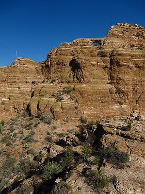
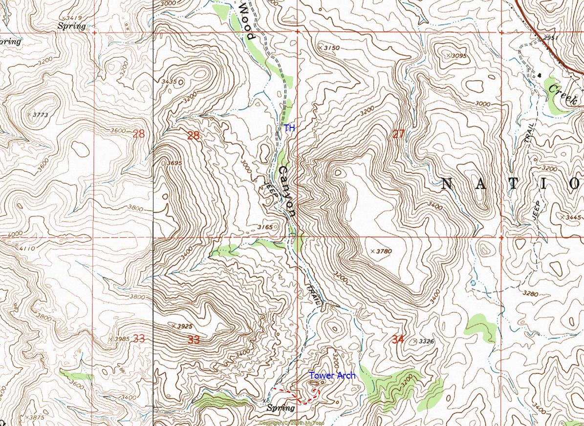
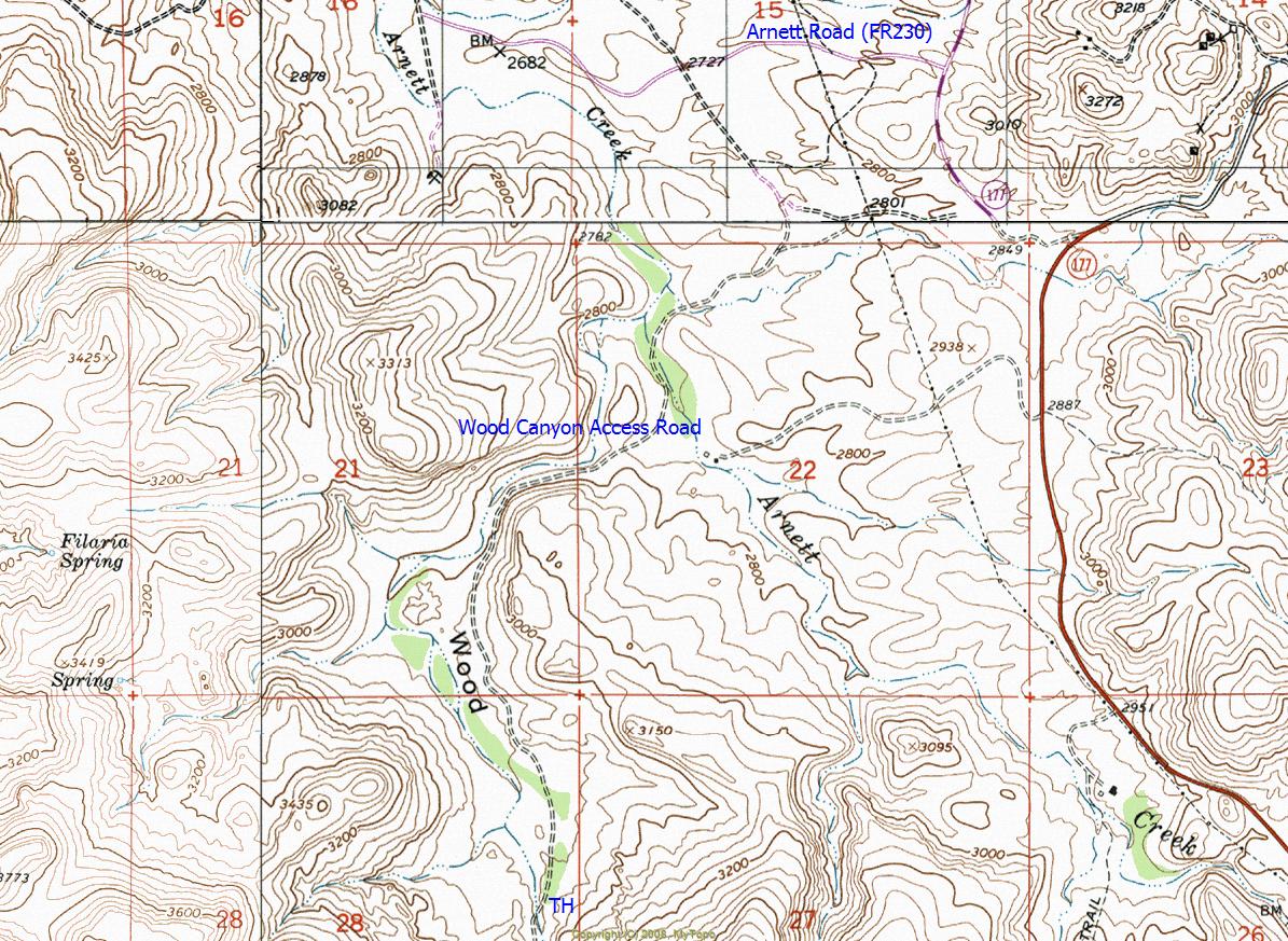
Off-trail route accessing a unique moderate sized natural arch situated on a tower of rock overlooking Wood Canyon. The hike as posted ends at the summit of an adjoining secondary butte with great views of the arch and its beautiful surroundings. Truly a special destination.


Hike End: Lat. 33 Degrees/12'/34.47"/N & Long. 111 Degrees/06'/44.12"/W (3,429 Feet)
  • guide related image guide related image
    guide related


Check out the Official Route and Triplogs.
Leave No Trace and +Add a Triplog after your hike to support this local community.

One-Way Notice
This hike is listed as One-Way.

When hiking several trails on a single "hike", log it with a generic name that describes the hike. Then link the trails traveled, check out the example.
WARNING! Hiking and outdoor related sports can be dangerous. Be responsible and prepare for the trip. Study the area you are entering and plan accordingly. Dress for the current and unexpected weather changes. Take plenty of water. Never go alone. Make an itinerary with your plan(s), route(s), destination(s) and expected return time. Give your itinerary to trusted family and/or friends.

 Permit $$
None


 Directions
or
 Road
High Clearance possible when dry

To hike
Mesa (East Valley) - US60 - Superior - State Route 177 - Arnett Road (FR230) - Arnett Creek (Unmarked "high-clearance" road) - Wood Canyon (Unmarked "high-clearance" road) - Destination (Also see posted GPS driving route)
page created by ssk44 on Jan 09 2011 2:35 pm
 90+° 8am - 6pm kills
helpcorrectionissue

end of page marker