Route Editor

| Guide | ♦ | 6 Triplogs | 1 Topic |
details | drive | permit | forecast | map |
stats |
photos | triplogs | topic | location |
| 64 | 6 | 1 |
Canyons are inherently risky. Flash floods occur without notice on sunny days. Technical skills & surrounding topography knowledge required yet does not eliminate risk.
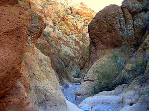
East side canyon off Box Canyon Trail Loop by AZLumberjack  Overview OverviewThis hike begins at the start of the Box Canyon Trail, but instead of entering Box Canyon, we will enter the canyon that joins from the immediate right. The hike will continue for about 3 miles up this canyon and then join with the Martinez Canyon Trail for about 2 miles. The trail continues up and over a saddle, then down the opposite side and finally joining with Box Canyon Road leading South to the Box Canyon Trail and back to the starting point. Warning The drive from Hwy 79 on East Price Station Road to the Trail Head is about 14 miles of hard dirt, exposed rocks, mud holes, and loose gravel. The road is relatively flat and proceeds through the Gila River bottomlands to Box Canyon Trail's entrance. The route is accessible by high clearance vehicles such as pick-up and SUV. If the roads have not been recently maintained, do not enter with a low clearance vehicle.
Extreme caution should be exercised if rain is forecast. The canyon has near-vertical walls in many places, and the canyon is quite narrow for long stretches. If you are using a GPS, be prepared to lose the signal on occasion, as the canyon walls block some of the satellite transmissions. History There is very little historical value to this hike, but some side trips along the Martinez Trails will provide you with views of now deserted silver mines and old buildings. Hike The canyon floor is a combination of loose gravel and rocks, which make for easy hiking, and the rate of elevation gain is only slight. There are a few large rockfalls that require some bouldering but nothing that requires extra equipment. The canyon walls are vertical and narrow at the bottom, so at the first rockfall, there are no more 4-wheelers around, and the hike is quiet and scenic. Many of the canyon walls are covered with a layer of green moss, which adds an interesting perspective to the normal rock as they seem to resemble a velvet texture when viewed from a distance. There is a lot of greenery along the base of the canyon, but it's easy to pick your way through without getting all chewed up by the thorns, and in some places, it continues well up the side walls. There were many, now dry, waterfall areas. I can only imagine how incredible they would look if water were flowing (but I think that if water were flowing, the area would be almost inaccessible). The only way to see the sights with water flowing would be to start at the top of the canyon (off Martinez Trail) and work your way down to those falls, and someday I hope to make that trip. Water Sources There are no free-flowing springs along the trail, so be sure to bring sufficient amounts of water along. Camping There are several sites along the route where hikers may camp off the main trail, and an ample supply of firewood can be found along the trail. Check out the Triplogs. Leave No Trace and +Add a Triplog after your canyon trip to support this local community. | |||||||||||||||||||||||||||||||||||||||||||||||||||||||||||||||||||||||||||||||||||||||||||||