Route Editor

| Guide | ♦ | 17 Triplogs | 0 Topics |
details | drive | no permit | forecast | 🔥 route |
stats |
photos | triplogs | topics | location |
| 128 | 17 | 0 |
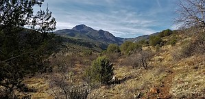
The never ending climb by topohiker   I started at 9:20 am from the City Creek TH. The elevation is of the TH is 3480. The trail begins across the road from the TH. There are no signs for the trail. The trail starts to climb and climb. You follow the ridgelines. I started at 9:20 am from the City Creek TH. The elevation is of the TH is 3480. The trail begins across the road from the TH. There are no signs for the trail. The trail starts to climb and climb. You follow the ridgelines.At about 5.5 miles into the hike, you hit the Red Hills trail. Interestingly, this is part of the AZ trail, and there's no sign indicating that. By this point, you've climbed about 2,500 feet! This near your high point of 6275. The Mazatzal divide trail was easy to follow. There are a couple of minor overgrowth spots, but nothing too bad. There are a couple of fallen trees here and there. The trail more or less flats out for about a mile. You go through a significant downfall area, and the trail gets obscured. Just keep going straight. There's a couple of downs and up's but nothing like the climb up. You go through another significant downfall area, keep going in a straight direction, and you should be fine.
I made it to the North Peak trail intersection. My GPS also called this area "The Park." There was a nice campsite here with a garbage can. There was also some trail maintenance tools here :) I was just a short distance from the Wet Bottom creek, so I decided to check it out. It was bone dry, but it so deep that if it was full, my bottom would have been wet! Just past the Wet Bottom creek is the Willow trail, but the Mazatzal divide disappeared once I crossed the creek. This was another major downfall area. It was past my turn around time, so I decided to come back another day (via the North Peak trail). (After I got home and mapped out my GPS route on the maps, It looks like the Mazatzal divide trail changed direction at the Wet Bottom creek. It moves about 100 feet to the right after it crosses the creek. I'll verify this another day.) I headed back, and this time I followed the trail out, and I still got a little messed up by the downfall area. It would help out if you download my GPS track to guide you through this section. The views on this hike were great. In a short amount of time, you're in the middle of the remote Mazatzal mountains. You have some great views. This part of the trail is almost 100% exposed. The higher elevations help out with the heat. Check out the Official Route and Triplogs. Note This is a more difficult hike. It would be unwise to attempt this without prior experience hiking. Leave No Trace and +Add a Triplog after your hike to support this local community. | |||||||||||||||||||||||||||||||||||||||||||||||||||||||||||||||||||||||||||||||||||||||||||||||||||||||||||||||||||||||||||||||||||||||||||||||||||||||||||||||||||||||||||||||||||||||||||||||||||||||||||||||