username
X
password
register
for free!
help


Valley of the Gods, UT

Guide 11 Triplogs  0 Topics
  3.6 of 5  
Fav
Wish
2
details
drive
no permit
forecast
route  
stats
photos
triplogs
topics
location
114 11 0
Statistics
tap row or icons for details
Distance One Way 17 miles
Trailhead Elevation 5,317 feet
Avg Time One Way 1 hour
 Backpack Yes
feature photo
Photos Viewed All MineFollowing
15  2019-02-14 Stoic
5  2018-10-15 Stoic
10  2018-04-07 Steph_and_Blake
3  2017-10-04 AZWanderingBear
11  2017-07-29 Stoic
18  2014-04-21 AZ_Step
9  2013-11-03 RickVincent
7  2013-05-10 outdoor_lover
Page 1,  2
Author
author avatar Guides 100
Routes 63
Photos 2,548
Trips 184 map ( 820 miles )
Age 76 Male Gender
Location Grand Junction, CO
Historical Weather
Trailhead Forecast
Radar Map
Expand Map
Preferred Oct, Apr, May, Mar
Seasons   Early Spring to Early Winter
Sun  5:53am - 6:43pm
Official Route & 3 Rts
 
0 Alternative


Valley of the Gods is a scenic drive in southeastern Utah, near Bluff and Mexican Hat. Often called a mini-Monument Valley it has similar formations and geology, without the hordes of tourists. Furthermore, being BLM land, there aren’t the restrictions on hiking and camping associated with Monument Valley.


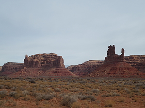
The Valley of the Gods road connects UT-163 (west of Bluff) and UT-261 (north of Mexican Hat and just south of the Moki Dugway). The road itself is 17 miles long, made of dirt and gravel, and winds its way through the valley and up and down numerous washes. We’d read that it’s recommended you have a 4x4, high-clearance vehicle, but the road conditions were such that anything but a low-clearance sports car could have made the drive. Having said that, it could be a whole other story in wet weather, especially on the steep sections.
remove free decal offer
Scattered along the drive are dozens of campsites, many of which would offer good sunrises and sunsets. Unfortunately all are located right next to the road. So, if you’re in search of complete solitude, bring your backpack or find another locale. It also looked like the kind of place that you’d want to get to early in order to secure a site as about 70% of them were occupied the morning we drove through. Another option would be to stay at the Valley of the Gods B&B on the northwest end of the road.

Note that there are no facilities along the drive, so bring plenty of water and make sure you have enough fuel to get to the nearest gas station.

If you’re interested to know the names of the formations, take along a map such as National Geographic Trails Illustrated - Grand Gulch Cedar Mesa Plateau. You won’t need it for route-finding, though.

Lastly, it looked like a fun place for both motorcycling and bicycling. However, there are some blind curves and “up-downs” that might cause spikes of adrenaline if encountering vehicles going in the other direction!


    Check out the Official Route and Triplogs.
    Leave No Trace and +Add a Triplog after your scenic drive to support this local community.
    WARNING! Hiking and outdoor related sports can be dangerous. Be responsible and prepare for the trip. Study the area you are entering and plan accordingly. Dress for the current and unexpected weather changes. Take plenty of water. Never go alone. Make an itinerary with your plan(s), route(s), destination(s) and expected return time. Give your itinerary to trusted family and/or friends.

     Permit $$
    None


     Directions
    or
     Road
    FR / Dirt Road / Gravel - Car Okay

    To scenic drive
    From Bluff, take UT-163 west for 17 miles. Turn right onto the signed road for Valley of the Gods.
    page created by PaleoRob on Apr 19 2018 12:55 pm
     90+° 8am - 6pm kills
    helpcorrectionissue

    end of page marker