 Route Editor

| Guide | ♦ | 21 Triplogs | 0 Topics |
details | drive | no permit | forecast | route |
stats |
photos | triplogs | topics | location |
| 203 | 21 | 0 |
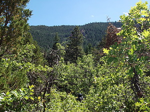
Alone in the North by VVebb  Overview OverviewThis hike begins at the base of the East Rim of the Kaibab Plateau, about 7 miles (as the crow or California Condor flies) west of the Colorado River. When you reach the rim, you can see many miles of the surrounding countryside, including an elevated view of the Grand Canyon. The vast majority of the trail is in the Saddle Mountain Wilderness. This trail receives very little use, as evidenced by the thick overgrowth of oak and other trees in the middle one-third of the path. I gave this hike a route-finding rating of 3.0, which could change for the better if somebody came through with a machete or change for the worse if the trees continue to grow and choke the trail further. However, you're in a canyon, so it would be tough to get "lost." Planning The 20-mile stretch of the dirt road leading up to the trailhead is open to camping. Due to the remoteness of the trailhead and the benefit of getting an early start during the summer, you may want to camp somewhere along this stretch and start hiking the next morning.
Hike As you leave the trailhead, you immediately drop into a wash, which is the lower extent of North Canyon. High desert flora vegetates the wash, but junipers line the canyon's edges. This part of the trail heats up very quickly. Starting early morning is recommended. The first major landmark is a large alcove containing a notable amount of Indian rock art. (Petroglyphs? Pictographs? I can't remember which.) After a mile or two, the high desert flora gives way to more significant vegetation (which is a mixed blessing because it offers shade but was VERY overgrown as of June 2010). A couple of miles later, the thick vegetation opens up into ponderosa pine forest. The pines eventually give way to mixed conifer forests. Somewhere near the transformation from pine forest to mixed conifer forest, you'll reach (1) the lower extent of the perennial creek and (2) the junction with Trail #7, which goes about 1.5 miles up to the East Rim Viewpoint, although not necessarily in that order. Assuming that you're doing this as a backpacking trip, there are two logical options for camping: (1) camp in the canyon near the creek -- taking care to honor Forest Service regulations regarding minimum campsite distance from the creek -- or (2) hike up to the East Rim and camp up on the top. I recommend that you set up camp in the canyon near the creek, grab a flashlight, hike up to the East Rim, enjoy the changing colors of the countryside as the sun sets, and then hike back down to camp in twilight. Notably, the East Rim faces east, so sunset will probably pale in comparison to the sunrise.
Check out the Official Route and Triplogs. Note This is a moderately difficult hike. Leave No Trace and +Add a Triplog after your hike to support this local community. One-Way Notice This hike is listed as One-Way. When hiking several trails on a single "hike", log it with a generic name that describes the hike. Then link the trails traveled, check out the example. | ||||||||||||||||||||||||||||||||||||||||||||||||||||||||||||||||||||||||||||||||||||||||||||||||||||


