Route Editor

| Guide | ♦ | 3 Triplogs | 0 Topics |
details | drive | no permit | forecast | 🔥 route |
stats |
photos | triplogs | topics | location |
| 33 | 3 | 0 |
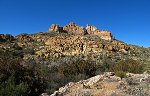
 Follow the posted 5.2 miles one way Official GPS Route for this enjoyable and scenic "off-trail" hike up canyon utilizing a well-maintained horse "use route" and the easy to follow Wood Canyon Creek drainage for 4.5 miles to connect with AZT- Passage#17. Follow the posted 5.2 miles one way Official GPS Route for this enjoyable and scenic "off-trail" hike up canyon utilizing a well-maintained horse "use route" and the easy to follow Wood Canyon Creek drainage for 4.5 miles to connect with AZT- Passage#17.Then an additional 0.70-mile hike north(up) AZT Passage 17 to your turnaround location at a scenic high saddle just off the AZT for views south to the White Canyon Wilderness, north to Picketpost Mountain, and the Superstition Wilderness with distant Weavers Needle views. Check out the Official Route and Triplogs. Leave No Trace and +Add a Triplog after your hike to support this local community. | ||||||||||||||||||||||||||||||||||||||||||||||||||||||||||||||||||||||||||||||||||||||||