Route Editor

| Guide | ♦ | 14 Triplogs | 0 Topics |
details | drive | permit | forecast | route |
stats |
photos | triplogs | topics | location |
| 55 | 14 | 0 |
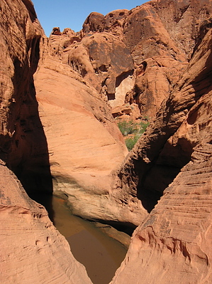
Paiute Tinaja by autumnstars This is a short hike past petroglyph-covered rocks to a tinaja in lovely red sandstone. Suitable (and fun) for hikers of all abilities, including young children. Warning Even though this hike is short, it would be foolish to hike anywhere in the Mojave Desert without taking some water.
History mixed with legend has it that a Southern Paiute nicknamed "Mouse" used the canyons in the Valley of Fire to hide out from the law in the late 1890s. After months of searching, a posse finally found him and he was killed in a gunfight. It is thought that he survived during the ensuing months by getting water from the tinaja now named Mouse's Tank. On the rock walls of the wash, there are literally hundreds of petroglyphs, hinting that the tinaja likely held water long before Mouse arrived on the scene. Hike Upon exiting the parking area, the trail immediately drops down into a wash with roughly 10-ft high walls of sandstone. The wash has a soft sand surface scattered with larger sandstone blocks, making for easy walking. Some interesting plants such as white-stemmed milkweed (Asclepias albicans) and catclaw acacia (Acacia greggii) grow in the bottom of the wash. Soon, you notice that the sandstone walls have a very well-developed coating of desert varnish and you start to see many petroglyphs - human, animal, and geometric forms. Shortly, the wash turns north and you reach Mouse's Tank. Scrambling up the sloped rocks on the left of the tinaja affords an amazing view out over the maze of sandstone. This is where the trail officially ends, but you can continue beyond with minor scrambling effort and explore a seemingly endless collection of sandstone hills, ledges, and canyons. Just don't get lost! You will have to exit the way you came in. Check out the Official Route and Triplogs. Leave No Trace and +Add a Triplog after your hike to support this local community. | |||||||||||||||||||||||||||||||||||||||||||||||||||||||||||||||||||||||||||||||||||||||||