Route Editor

| Guide | ♦ | 2 Triplogs | 0 Topics |
details | drive | no permit | forecast | map |
stats |
photos | triplogs | topics | location |
| 3 | 2 | 0 |
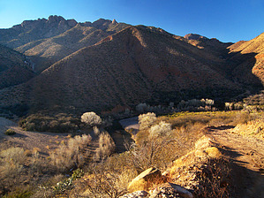
 Overview: A combination 4wd road and off-trail hike that crosses the San Francisco River upstream of Clifton, and takes one to Evans Point, a rocky limestone bluff with great views up and down the River. There are several caves in the bluff accessible only by technical rock climbing. Overview: A combination 4wd road and off-trail hike that crosses the San Francisco River upstream of Clifton, and takes one to Evans Point, a rocky limestone bluff with great views up and down the River. There are several caves in the bluff accessible only by technical rock climbing.Evans Point could also serve as a starting point for longer hikes up to Dorsey Gulch, Sycamore Gulch, and Sardine Falls. Check out the Triplogs. Leave No Trace and +Add a Triplog after your hike to support this local community. | ||||||||||||||||||||||||||||||||||||||||||||||||||||||||||||||||||||||