Route Editor

| Guide | ♦ | 1 Triplog | 1 Topic |
details | drive | no permit | forecast | 🔥 route |
stats |
photos | triplog | topic | location |
| 48 | 1 | 1 |
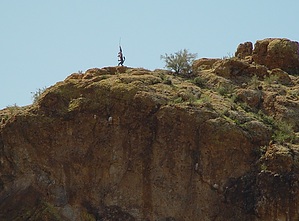
Find the flagstaff by sventre  Background BackgroundWhile floating on Saguaro Lake a few weeks ago, I happened to note the flagstaff of what I have since been told is the mascot of an AZ National Guard Unit. It sits high on a bluff, east of Bagley Flat, and overlooks the river's northern banks. My goal was to find that desert oddity from a point beginning at the Rolls. The accompanying GPS route can be driven or hiked, as you prefer, and it will get you within 1/4 mile of the final location (33.56492N, 111.46762W). Begin at the Four Peaks turnoff from SR87. Hike I decided to drive the greater portion of the route, through the winding sandy trails and up along the ridgeline heading south toward the lake. You will encounter several service road markers along the way, but maintain a southerly heading when faced with an option. After driving along the ridge for some time and enjoying the 360 views, it was time to dismount and make my way the rest of the trip on foot.
Continuing south from the Tank, I decided first to mount Peak 2074. The climb, while steep and loose footing at points, is relatively straightforward. Unfortunately, there was a considerable amount of cholla covering the ground this day, and so carrying my hiking buddy was the only viable option. Reaching the top of the peak presented terrific views of Cottonwood Creek, the river, and the distant southern Supes; but, my intended goal was nowhere in sight. I decided to head west across the flat top of 2074, and after a short distance, finally caught a glimpse of the flagstaff. As luck would have it, descending 2074 and regaining a nearly equivalent elevation on the southwest peak would be more of a challenge than I was expecting. Thus, I decided that carrying the dog most of that way was not something I would do today. This was a highly desirable alternative to hiking the lengthy sand and gravel of Cottonwood Creek for those wanting to reach the river from the north. The views are splendid, and there is relatively easy access to the Creek from Brownie Tank, allowing for much less trudging to get to the river. I was able to reach the point from which I began the hike without the necessity of engaging 4WD. Descending into Brownie Tank, however, may require 4WD upon exiting. There is an alternate jeep trail heading northwest from Brownie Tank, which may allow for 2WD high clearance, but I didn't have a chance to investigate. For these reasons, I am posting this as 4WD necessary. Check out the Official Route and Triplog. Leave No Trace and +Add a Triplog after your hike to support this local community. | |||||||||||||||||||||||||||||||||||||||||||||||||||||||||||||||||||||||||||||||||||||||||||||||||||