username
X
password
register
for free!
help
 
  🔥

Barnhardt Canyon, AZ

Guide 13 Triplogs  0 Topics
  4.4 of 5  
Fav
Wish
4
details
drive
no permit
forecast
🔥
route  
stats
photos
triplogs
topics
location
240 13 0
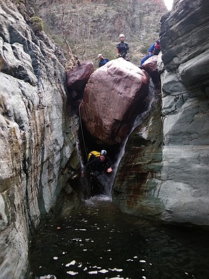
Canyons are inherently risky. Flash floods occur without notice on sunny days. Technical skills & surrounding topography knowledge required yet does not eliminate risk.
Canyoneering
Consensus
View 6
Grade3
WaterC
Risk
TimeIII
Statistics
tap row or icons for details
Distance Round Trip 6 miles
Trailhead Elevation 4,186 feet
Elevation Gain 2,000 feet
Kokopelli Seeds 16
 Interest Off-Trail Hiking, Seasonal Waterfall & Seasonal Creek
unreported if dogs are allowed
editedit > ops > dogs to adjust
feature photo
Photos Viewed All MineFollowing
Will recalculate on button tap!
4  2025-03-22 azhiker00
11  2021-08-22 RedwallNHops
12  2017-02-08 o2bav8
14  2014-05-03 desert_boonie
8  2014-03-02 azflyguy
4  2013-05-01 toddak
81  2011-03-31 Vaporman
65  2011-02-13 Vaporman
Page 1,  2
Author
author avatar Guides 16,843
Routes 17,472
Photos 24
Trips 1 map ( 6 miles )
Age 28 Male Gender
Location HAZ, TrailDEX
Historical Weather
Trailhead Forecast
Radar Map
Expand Map
Preferred Oct, Nov, Mar, Apr
Sun  6:03am - 6:45pm
Official Route & 1 Rt
 
0 Alternative
 
Historic Fire Perimetersacres
🔥 Barn 20020.9 mi*
🔥 2004 Willow Fire120k
🔥 2004 Willow117.2 mi*
🔥 View (All) - over Official Route 🔥
*perimeter length in miles


remove free decal offer

 
Guide Needed
Publish Full Detail Guide


Use +Add above to share photos and triplogs
Overview
Amazingly colorful and adventurous canyoneering route thru the main canyon of Barnhardt Canyon with half a dozen rappels up to 80ft, with loads of swimmers, down climbing & rock hopping on slippery rock...


    Check out the Official Route and Triplogs.
    Leave No Trace and +Add a Triplog after your canyon trip to support this local community.
    WARNING! Hiking and outdoor related sports can be dangerous. Be responsible and prepare for the trip. Study the area you are entering and plan accordingly. Dress for the current and unexpected weather changes. Take plenty of water. Never go alone. Make an itinerary with your plan(s), route(s), destination(s) and expected return time. Give your itinerary to trusted family and/or friends.

     Permit $$
    no fees or permits reported

    if incorrect tell us about it


     Directions
    or
     Road
    FR / Dirt Road / Gravel - Car Okay

    To Barnhardt Trailhead
    From the corner of SR87 & SR260 in Payson go south on SR87 for 14.5 miles to the signed turnoff for Barnhardt trailhead (forest road 419). Follow FR419 5 miles to its end. The parking area is fairly large. Barnhardt trailhead is located at the west end of the parking area. From Phoenix take SR87 north out of Mesa to Payson. The turnoff to the trailhead is 4mi north of the 188 intersection. (think rest stop)

    From PHX (I-10 & AZ-51) 83.4 mi - about 1 hour 45 mins
    From TUC (Jct 1-10 & Grant) 182 mi - about 3 hours 4 mins
    From FLG (Jct I-17 & I-40) 126 mi - about 2 hours 31 mins
    page created by Vaporman on Feb 14 2011 9:37 pm
     90+° 8am - 6pm kills
    helpcorrectionissue

    end of page marker