 Route Editor

| Guide | ♦ | 3 Triplogs | 2 Topics |
details | drive | permit | forecast | map |
stats |
photos | triplogs | topics | location |
| 38 | 3 | 2 |
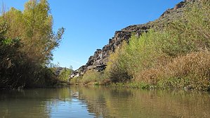
An enjoyable route to wrinkly feet. by Sarae  The Bill Williams River Gorge is a seldom visited canyon accessed through Alamo State Park in the Rawhide Mountain Wilderness. It features steep canyon walls, narrows, side canyons, sandy beaches, beaver dams, and of course, multiple water crossings. There is no established trail through the gorge, but occasionally you will find a use-trail along the banks. The Bill Williams River Gorge is a seldom visited canyon accessed through Alamo State Park in the Rawhide Mountain Wilderness. It features steep canyon walls, narrows, side canyons, sandy beaches, beaver dams, and of course, multiple water crossings. There is no established trail through the gorge, but occasionally you will find a use-trail along the banks.The water flow is controlled by the Army Corps of Engineers at the Alamo Dam, which was built in 1968. The Dam's creation greatly affected the flood patterns and caused major changes in the river corridor habitat. However, the gorge still contains a lush riparian zone with enough wildlife and vegetation to keep a hiker content. According to U.S. Fish & Wildlife, the average flow rate is 50 ft3/s, but you will want to check the current conditions before hiking the canyon as there are dam releases when Alamo Lake reaches high levels. The flow was around 29 ft3/s below the dam when we went in January.
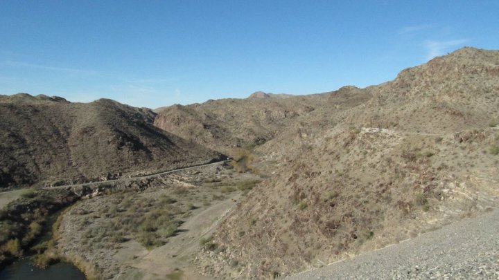
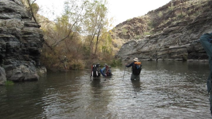
On another note, in late winter and spring, the gorge may be closed to hiking due to nesting bald eagles. Call the Lake Havasu BLM office to get up-to-date info. Hike: Park at the lot for the Bill Williams overlook and picnic area(fee required for overnight parking). I'm calling this the TH. It features a fantastic, Jetson's-esque picnic shelter. Walk back up to the Alamo Dam Access Road and follow it to the right. You will come to a gate with a no trespassing sign, but apparently, that just means no trespassing by any other means than walking. You can pass to the left of the gate. From here, keep following the road down into the canyon. Make a quick stop to check out the Dam and capture a couple of pics of the lake and the entry to the gorge. Once you get to the bottom of the canyon(about 1.25 miles), you will find the gaging station. Pass it, staying high and to the left, and going up and over a jumble of rocks and concrete. A side canyon comes in from the right and the river goes left. There is a use trail that will lead you across a sandy bench and towards the first of many water crossings. The second crossing was at the first narrowing of the canyon, and it was the only place where we had to get in over waist high. We were grateful for the gentle flow rate of the river. The bottom of the river was very muddy here, making it difficult to quickly move through this crossing. The water crossings are very frequent from this point, but if you search, there are generally routes that you can take to avoid getting any deeper than your knees. Footing for the majority of crossings required attention as the conditions of the stream bottom varied. We did encounter a beaver dam at one point that forced us to scramble along some ledges on the left side of the canyon, but this was done easily with some careful footwork. The river banks are often thick with willow saplings and other low growing vegetation. This can make navigating the banks to find shallow crossings more of an adventure. Side canyons join the main gorge at several points along the way. These canyons looked quite inviting, and some are said to be home to small waterfalls. We passed many sites that seemed suitable for camping, but we chose to stop and camp at about 3 miles into the canyon. The gorge continues for about another 2 miles before opening up into the Bill Williams River Valley. I'm sure a few really pleasant days could be spent exploring all this place has to offer...if you like that kind of thing. The way out is the way you came in. There is camping at Alamo Lake State Park if you wish to just day hike the gorge. There are full amenities available, including showers. Gate Policy: If a gate is closed upon arrival, leave it closed after you go through. If it is open, leave it open. Leaving a closed gate open may put cattle in danger. Closing an open gate may cut them off from water. Please be respectful, leave gates as found. The exception is signage on the gate directing you otherwise. Check out the Triplogs. Leave No Trace and +Add a Triplog after your hike to support this local community. | ||||||||||||||||||||||||||||||||||||||||||||||||||||||||||||||||||||||||||||||||||||||||||||||


