Route Editor

| Guide | ♦ | 7 Triplogs | 0 Topics |
details | drive | no permit | forecast | 🔥 route |
stats |
photos | triplogs | topics | location |
| 41 | 7 | 0 |
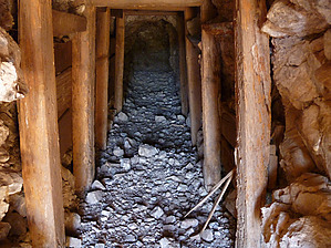
Hiker's Choice by sventre   Background BackgroundBomboy Mine is an abandoned dig that once produced Chrysocolla, Copper, and Limonite. Today, it shows the scars of surface mining exposing colorful rock formations and rich red soil. Chunks of the minerals are still scattered about the hillside and along the switchback trails that were once used by the mining operation. The drive to the mine can be accomplished in a high clearance vehicle, but since there are some wash crossings, it is not recommended the make this hike when wet weather is threatening or immediately following a period of rain. This morning, some 2 days after a weekend of rain, the roads and washes were dry. If you enjoy "Willow Springs Canyon" type hiking you should enjoy most of this trail as it is quite similar except that the Roblas Canyon floor has more gravel than sand. Hike This hike is a circle that can be made in either direction; and, from nearly any starting point you choose if you have high clearance 4WD. The reason this is so is that both the canyon and the jeep trails which connect to make this loop can be negotiated almost the entire route by a stock 4WD vehicle. Fortunately, this weekday morning I didn't encounter any ATVs or any other vehicle until I had nearly completed the circuit. The GPS route begins at a point on the Bomboy Mine Road a little more than a half-mile west of the mine area. At this point, you can park and immediately enter the wash that will lead you to the canyon. Neither the wash nor the canyon is marked with cairns, but route finding is pretty much idiot-proof.
Again at this point, you have the choice of continuing in the wash or hiking the jeep trail that climbs out of the wash. Again, I chose the latter and was treated to views across the horizon in all directions as the trails ran across a ridge connecting individual hills. Just before the jeep trail reconnects with Bomboy Mine Rd. [33.31721N, 111.20528W] I noticed an adit to a mine shaft that doesn't appear on my topo map. As you proceed along Bomboy Mine Rd. turn right [33.31846N, 111.20904W] and climb the trail a short distance. The mine itself is in fairly good condition, and the supporting timbers seemed reasonably sound. It only goes about 50 feet into the hillside, I felt comfortable inspecting the interior, but the decision is yours. At this point, I continued to climb the hill upon which the mine shaft was located, crossed over the top, and descended into the wash which then reconnected with the Bomboy Mine Rd. You may feel more comfortable retreating down the hill from the mine shaft and continuing along the road to your point of beginning. As stated earlier, there wasn't much about this hike that stands out. Oddly, I did see what seemed to be miniature versions of more prominent Superstition Mtn. locations. One was what had the shape and appearance of the Flatiron. Check out the Official Route and Triplogs. Leave No Trace and +Add a Triplog after your hike to support this local community. | ||||||||||||||||||||||||||||||||||||||||||||||||||||||||||||||||||||||||||||||||||||||||||||||||||||||||||