 Route Editor

| Guide | ♦ | 10 Triplogs | 1 Topic |
details | drive | no permit | forecast | 🔥 route |
stats |
photos | triplogs | topic | location |
| 74 | 10 | 1 |
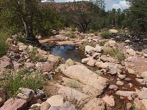
Take a Quick Dip at Midnight by jacobemerick   Overview OverviewConnector trail deep in the Mazatzal Wilderness with several appealing features of its own. A fundamental piece of the Midnight Mesa Loop and could be used for longer, multi-day trips that include Red Hills and Deadman Trail. This description will start at the southern end, which as of 2018 is the least appealing half. Warning The entire trail is within the Willow Fire burn area, and some sections were more heavily damaged than others. Between the old burn, remote location, and low traffic, it may be difficult to research or predict conditions.
Reaching the southern end of the trail is most easily done from Sheep Bridge, climbing 14 miles on Willow Springs #223. There is no trailhead sign at the junction, just a lonely post with a few nails, and there isn't much of a tread to point in the right direction either. Simply head north through the past of least resistance, avoiding the thorny stuff and watching for an occasional cairn. The first few hundred yards may be discouraging. There are a lot of rolling rocks underfoot and it's easy to wander off-trail while avoiding the brush. When the drainage to the east becomes more pronounced so does the trail, as it follows the curve of the bank from a safe distance. A section of spared forest grants shade, and the tread is sometimes very well defined between the rocks. It may still be tricky to follow the trail through the tributaries. At .8 miles it finally crosses the drainage on the east and follows the opposite bank. After crossing the drainage the forest begins to fade into thick brush and deadfall. Right before it crosses the main branch of Wet Bottom Creek at 1.1 miles things get very confusing - it may be easier to simply hack towards the creek and then re-discover the trail on the other side. Because, on the north side of Wet Bottom Creek, the trail makes a drastic change for the better. Large cairns, wide tread, cleared brush, and even an open corral all show up in short order. From here to Red Hills is quite enjoyable. There's still a healthy climb to make, almost 600' in all. First, it winds up a hillside before entering a flat, open valley, then it darts in and out of a rocky tributary, then it zips up a steep slope with a few tight switchbacks until it finally meets up with Red Hills Trail. Most of this is unshaded and south-facing, so it can get pretty toasty in the afternoon sun. On top there is a sign, which was burned into pieces as of 2018, though there are large cairns to mark the junction. Now you just have to figure out which way to go next: take Red Hills to the left for 20 miles to Sheep Bridge or Red Hills to the right for 11 miles to City Creek (or 15 miles to Doll Baby). Water Sources Several of the tributaries along the trail may have water, or Wet Bottom Creek itself. The most reliable source is likely Fuller Seep, located a mile east of the northern junction. Camping The corral near Wet Bottom Creek has plenty of camping opportunities. Fuller Seep, a mile from the northern end of the trail, is also a fantastic campsite. Check out the Official Route and Triplogs. Leave No Trace and +Add a Triplog after your hike to support this local community. One-Way Notice This hike is listed as One-Way. When hiking several trails on a single "hike", log it with a generic name that describes the hike. Then link the trails traveled, check out the example. | |||||||||||||||||||||||||||||||||||||||||||||||||||||||||||||||||||||||||||||||||||||||||||||||||||||||||||||||||||||||||||||||||||||||||||||||||||||||||||||||||||||||||||||||||||||||||||||||||||||||


