 Route Editor

| Guide | ♦ | 20 Triplogs | 2 Topics |
details | drive | no permit | forecast | 🔥 route |
stats |
photos | triplogs | topics | location |
| 273 | 20 | 2 |
A Mazzie Dutchman by jacobemerick   Overview OverviewA beautiful, varied trail in the western Mazatzal Wilderness providing a challenge that continuously pays off. The route is well-chosen and should be easy to track even without regular maintenance. Can be used with nearby trails to make for great backpacking trips, such as Sheep Bridge / Mountain Spring Loop and the more extreme Midnight Mesa Loop. Hike Reaching the western trailhead means driving to Sheep Bridge, which is a long haul over rough dirt roads (at least two hours for most). It's a great trailhead with multiple recreation possibilities, and the remote area keeps the crowd levels down. The drive does make for a hefty commitment for most day-hikers. Once you cross the bridge, you'll need to follow the Verde River Trail #11 for three-quarters of a mile before the start of the Dutchman Grave Trail, hopping over both Horse and Sycamore Creek along the way.
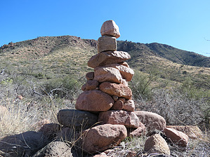
After a small climb around the side of a short hill, the mesa ends at 3.3 miles, forcing the trail up a sharp 400' climb. There are a few switchbacks to help catch the breath. On top of the saddle, a great view of the valley ahead opens up, where Sycamore Creek flows down from the Red Hills and joins with the Dutchman Grave springs. Trot down and enter the scenic valley. At 4.3 miles, you will cross the creek, and then over the next mile, the route plays along washes, passes the Red Hills Trail junction, swings into a few lovely riparian areas with established campsites, and passes at least two decent water sources. This is a good spot for a break (or an overnight) before the steeper half of the trail. At 5.4 miles, the trail goes through an old gate and leaves the valley behind, climbing the slope of 4165' before swinging off to a saddle on the side. Then it mostly stays level, darting in and out of a few drainages, with a few short climbs. This section of the trail may be difficult to follow, with multiple game trails crisscrossing the official route. Cypress Butte towers to the north, a distraction from the rough going. At 7 miles, the trail finally leaves 4165' behind, taking a saddle across to the bottom of Midnight Mesa and shooting up a rocky drainage, cresting around 4300'. For the next mile, the trail stays at the base of the mesa above, winding around to avoid some drainages to the south. This is pleasant going through open grasslands with big views opening up all around. Also, some of the largest cairns in the Mazatzals appear to live in this area - perhaps the grass makes them grow taller out here. At 9 miles, there is a short drop across one of the drainages and an 800' climb waiting on the other side. This final exhausting incline deposits you within an easy trot of the trail's eastern end, near the verdant Mountain Spring. Water Sources Both Lower and Dutchman Grave Spring are mostly dependable, though it may take some hunting around to find a pool large enough to pull from during dry times. The trough at Mountain Spring is dependable year-round. Camping Several good campsites sit around Dutchman Spring with fire rings and clearings for tents, usually within view of the trail. Mountain Spring is a relatively well-known site in the heart of the Mazatzals and has water, a fire ring, a table (!), and great shade. Gate Policy: If a gate is closed upon arrival, leave it closed after you go through. If it is open, leave it open. Leaving a closed gate open may put cattle in danger. Closing an open gate may cut them off from water. Please be respectful, leave gates as found. The exception is signage on the gate directing you otherwise. Check out the Official Route and Triplogs. Leave No Trace and +Add a Triplog after your hike to support this local community. One-Way Notice This hike is listed as One-Way. When hiking several trails on a single "hike", log it with a generic name that describes the hike. Then link the trails traveled, check out the example. | ||||||||||||||||||||||||||||||||||||||||||||||||||||||||||||||||||||||||||||||||||||||||||||||||||||||||||||||||||||||||||||||||||||||||||||||||||||||||||||||||||||||||||||||||||||||||||||||||||||||||||||||


