username
X
password
register
for free!
help
 
   🔥

Elephant Butte Loop, AZ

Guide 2 Triplogs  1 Topic
  3 of 5  
Fav
Wish
0
details
drive
permit
forecast
🔥
route  
stats
photos
triplogs
topic
location
11 2 1
Statistics
tap row or icons for details
Difficulty 0.5 of 5
Distance One Way 1.55 miles
Trailhead Elevation 2,279 feet
Elevation Gain 82 feet
Accumulated Gain 143 feet
Kokopelli Seeds 2.03
 Interest Off-Trail Hiking, Perennial Waterfall & Seasonal Creek
unreported if dogs are allowed
editedit > ops > dogs to adjust
feature photo
Photos Viewed All MineFollowing
10  2011-02-22 AZLOT69
1  2007-08-05 qvfd511
Author
author avatar Guides 16,843
Routes 17,472
Photos 24
Trips 1 map ( 6 miles )
Age 28 Male Gender
Location HAZ, TrailDEX
Associated Areas
list map done
Phoenix Region
Historical Weather
Trailhead Forecast
Radar Map
Expand Map
Preferred Feb, Jan, Dec, Nov
Sun  6:02am - 6:45pm
Official Route
 
1 Alternative
 
Historic Fire Perimeteracres
🔥 2020 Sawtooth Fire24.7k


remove free decal offer

 
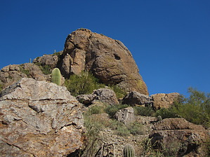
Overview: Mentioned in many books regarding Superstition Treasure, this hike offers a bit of Indiana Jones intrigue. A mine, petroglyphs, metates and Elephant Butte.


As of 2012 the area appears to be closed on private land.


    Check out the Official Route and Triplogs.
    Leave No Trace and +Add a Triplog after your hike to support this local community.

    One-Way Notice
    This hike is listed as One-Way.

    When hiking several trails on a single "hike", log it with a generic name that describes the hike. Then link the trails traveled, check out the example.
    WARNING! Hiking and outdoor related sports can be dangerous. Be responsible and prepare for the trip. Study the area you are entering and plan accordingly. Dress for the current and unexpected weather changes. Take plenty of water. Never go alone. Make an itinerary with your plan(s), route(s), destination(s) and expected return time. Give your itinerary to trusted family and/or friends.

     Permit $$
    AZ State Recreational Land Permits
    For hiking, driving & sightseeing purposes, you seek a recreational permit.
    Under "Recreational Land Use" in the link above.
    2022 - $15.00 individual
    2022 - $20.00 family limited to two adults and children under the age of 18
    Plus $1 processing fee
    The permitting process is quick, you will be emailed your permit instantly.

    Land Parcel Map


     Directions
    or
     Road
    High Clearance possible when dry

    To hike
    Elephant Butte Road 6.4 miles north of Silver King Road in Queen Valley. Park just past the Cattle guard and begin your adventure.
    page created by AZLOT69 on Feb 25 2011 10:42 am
     90+° 8am - 6pm kills
    helpcorrectionissue

    end of page marker