Route Editor

| Guide | 0 Triplogs | 0 Topics |
details | drive | permit | forecast | 🔥 route |
stats |
photos | triplogs | topics | location |
| 61 | 0 | 0 |
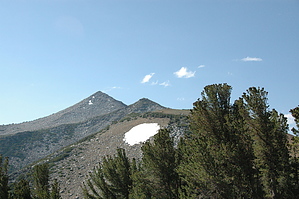
Very hard earned views by slegal Pyramid Peak can be viewed from many angles in the town of Mammoth Lakes. The farther west you go in town, the more the peak looks like a perfect pyramid. As you head east out of town, the peak ceases to look like a pyramid. Up close, the peak becomes a giant mass of granite boulders strewn about.
There are several possible routes to the peak. Some backcountry skiers have been known to come up from the Sherwin Lakes. Some approach the peak by climbing the scree chutes to the north of the Duck Lake Trail. The route that this hike description covers starts at the Heart Lake trailhead. The trail heads up a couple of switchbacks through an aspen forest before breaking out of the forest into an open brush covered slope. Soon you'll reach another switchback turn. This is where you depart from the Heart Lake Trail. You will head west on an unmarked trail into a small pine forest. The trail then turns north and heads up the southern slope of Sherwin Ridge. Gradually, the trail turns to a more northeasterly direction and heads up a very steep slope. Shortly, the trail flattens to a more gradual slope. At this point the trail begins to disappear as you approach a pine forest. Continue into the pine forest and travel in an east northeasterly direction. When you finally reach the end of the pine forest you will want to continue toward the east where the pine trees that line the uphill section of the ridge end near where the ridge drops off to the north. Resist heading southeast to the red mountain. The rocks there are very loose and you'll wear yourself out trying to climb it. There is lots of clearing in the rows of pines to the east and the slope is gentler with firmer soil. After you reach the top of the scattered pine forest the terrain flattens out. To the north is a granite outcropping that I call Granite Chief. To the south is the red mountain. You want to travel between the two and along the side of the red mountain. There are faint trails that you can pick up here. The climb is slight but the scree is very loose here. Soon you'll reach firmer ground and will travel down to the saddle between the red mountain, now to the west and a taller red mountain to the east. From the saddle you want to head up the taller red mountain. There is a faint trail. I recommend staying off of the faint trail because you can find firmer terrain to the left of the trail. Soon you'll reach the top of the red mountain and will pick up a more well worn trail. This trail will take you straight to a peak of black rocks. I recommend climbing straight up the spine of the peak. The sides are steep and loose with lots of opportunities to turn an ankle. The spine is more stable. When you come down off of the black rock peak your route is much less obvious. I have seen people climb up the rocky ridgeline. This is a pretty strenuous route. I chose to head straight through the rows of pines. This route is relatively flat which gives you some well needed rest from climbing. Eventually you will reach a large boulder strewn slope that heads up toward Pyramid Peak. This is where you want to go. This will be a very strenuous climb, but it's not technical. The open slope ends near the base of the ridgeline you've travel alongside and some low lying pine bushes. There is a trail here that travels off to your right. Bear off to the right. The trail ends abruptly. From the end of the trail I chose to climb up along the tops of these small waist high pines. Be careful here. There are lots of opportunities to hurt yourself among these little pines. You come out of the pine climb in a saddle between the ridge you travel alongside of and the final ascent to Pyramid Peak. Now you just need to pick a route up the boulders. You ascend approximately 500 vertical feet through the boulders until you reach a ridgeline that gradually rises to the final destination. You'll know that you've reached the summit of Pyramid Peak when you spot the wilderness boundary marker planted in the rocks at the top of the peak. By now you should be pretty tired. Take in the views, eat some food and rehydrate because the descent is almost as tough as the climb. Check out the Official Route. Note This is a more difficult hike. It would be unwise to attempt this without prior experience hiking. Leave No Trace and +Add a Triplog after your hike to support this local community. | ||||||||||||||||||||||||||||||||||||||||||||||||||||||||||||||||||||||||||||||||||||||||||||||||||||||