 Route Editor

| Guide | ♦ | 7 Triplogs | 0 Topics |
details | drive | permit | forecast | route |
stats |
photos | triplogs | topics | location |
| 145 | 7 | 0 |
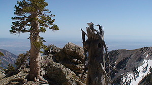
I Real Butt Kicker... With Great Views by slegal The access point most commonly used to access the Baldy Bowl Trail is the trailhead at Manker Flat that heads up to Mount San Antonio Falls. This is a dirt road. To get to the Baldy Bowl Trail you make a hard right turn on the dirt road rather than head straight toward the falls. When you reach the Baldy Bowl trailhead you will turn left off of the dirt road and head up a steep uphill switchback.
When you reach the Baldy Bowl trailhead you will have already travelled 1.1 miles. Now you're finally on your way up the Baldy Bowl Trail. My GPS says that the trailhead elevation is exactly 6,600 feet. At the trailhead you're only 150 higher than you were at the beginning of the hike and you already have 1.1 miles and 600 vertical feet of climbing under your belt. The trail travels up steeply along the south facing slope below the Devil's Backbone. Your first major milestone is the ski hut. The ski hut is 1.5 miles up the trail. It's also 1,550 feet higher than the trailhead. At 8,155 feet you're also still over 1,900 feet lower than the summit. To this point the climb up the Baldy Bowl Trail has been in a relatively straight northwest direction. From the ski hut the trail ends it's relatively straight northwest line to the summit and heads southwest toward a steep ridge. After crossing a creek just past the ski hut the trail heads up through a large boulder field. If you look up to your right you are looking right into the Baldy Bowl. It's not difficult to see where all of those boulders came from. Be thankful that you weren't there when the ridgeline let loose and sent all of those boulders crashing down to this spot. It is also worth noting that if you are here when there is snow in the bowl, you are very exposed to avalanche danger. While we're on the subject of snow, past the boulder field the trail begins heading up a steep set of switchbacks. The slope here is north facing. Consequently, it holds snow for quite a while due to a lack of sunshine. Consequently, the snow can be quite slippery, especially if it's icy. Many people climb this section with crampons when there is snow on the ground. If it's icy you probably don't want to climb this section without crampons. If there is no snow then all you have to deal with is a steep, loose slope. The trail levels out at the top of a knoll. If you're feeling energetic and adventurous the knoll heads off to your left for a little over a tenth of a mile. There is a nice little wind shelter at the end of the knoll and some nice views. If you're not feeling so adventurous, the Baldy Bowl Trail heads up to the right. You have a little over 1,200 more vertical feet of climbing and one mile of trail left. That means that the last mile of trail is very steep. Once again the trail is heading northwest. That means that there should be less snow during times when there is snow around. The trail snakes its way up the ridgeline above the Baldy Bowl. After you make it up the steepest part of the trail the trail levels out briefly at about the 9,600 foot elevation. There are a couple of side trails to the right that take you a couple hundred feet to the edge of the ridge. The views from here are spectacular, so enjoy. You still have a 460 foot climb in front of you. From here it is a relatively straight line the rest of the way. The trail reaches the summit after a 4.3 mile hike and a total elevation gain of almost 4,300 feet. Enjoy your stay at the top and recharge for the long and strenuous descent. Check out the Official Route and Triplogs. Note This is a moderately difficult hike. Leave No Trace and +Add a Triplog after your hike to support this local community. One-Way Notice This hike is listed as One-Way. When hiking several trails on a single "hike", log it with a generic name that describes the hike. Then link the trails traveled, check out the example. | ||||||||||||||||||||||||||||||||||||||||||||||||||||||||||||||||||||||||||||||||||||||||||||


