Route Editor

| Guide | ♦ | 18 Triplogs | 0 Topics |
details | drive | permit | forecast | 🔥 route |
stats |
photos | triplogs | topics | location |
| 150 | 18 | 0 |
confusing on your way back by DarthStiller  A new section of the Maricopa Trail has been completed along what will be the northern section of a loop making a circumference around metro Phoenix. A doable dayhike to complete a section of it starts at the Cave Creek Recreation Area and ends at New River Road. You will need to pay the parking fee for Maricopa County parks. A new section of the Maricopa Trail has been completed along what will be the northern section of a loop making a circumference around metro Phoenix. A doable dayhike to complete a section of it starts at the Cave Creek Recreation Area and ends at New River Road. You will need to pay the parking fee for Maricopa County parks.The Go John Trail is now considered a segment of the Maricopa Trail and is the shortest way through the Cave Creek Recreational Area to the new segment of the MT outside the park. Once you get to the northern boundary of the park, a prominent sign is there to show you to head to your left (west) to continue on the Maricopa Trail.
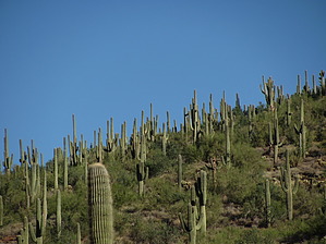
Follow this until you get to a metal marker indicating that you should turn right (north). At this point, you're on a well-established dirt road. Take this road a few hundred yards north and then west again. The road will turn south but a single track is visible continuing west and through a wash and some vegetation again. At this point to the south are homes, some of which will back right up against the trail. Also at this point, 1.3 miles from the end of the Go John Trail, you will encounter the junction of a spur of the Maricopa Trail that connects over from the Spur Cross Recreational Area as described by Moovyoaz. Not long after this trail junction, there is also a sign that indicates that this section of the trail is maintained by the Town of Cave Creek. 2.1 miles after the junction of the Go John Trail is another trail junction that heads northwest. This section of trail will take you to the summit of Apache Peak, which you can see looming ahead of you to your right (NW). South of the houses there are some roads and empty areas that might be good for parking to try this peak as a shorter dayhike. From the maps I saw, it looks like 24th St. and 26th St. will take you up into this area from the Carefree Hwy. After this trail junction, the trail heads downhill a little more and then begins to ascend where it crests at a saddle just south of Apache Peak. The south slopes of Apache Peak have quite a lot of saguaros, making for some nice scenery. At this point, the trail had made some distance from the development to the south and things seem a little more remote. That won't last long because once you make the crest of the saddle, you can see more development ahead of you creeping eastward from New River Road. Also ahead will be a prominent unnamed butte looming over the housing. After you get down from the saddle/hill, the single track ends at a dirt road. Continue west and south along this road for about a quarter to a half-mile. Other roads will intersect with this one along the way. This makes it confusing on your way back because the single track is not marked well if you're heading east. On my way back I missed the single track and had to use my GPS to follow my track of where I had been. I met some people on my way back who were also looking for this single track several times from west to east and had never found it until they followed me. Soon the road will make a hard right to the west again, heading straight for New River Road. At this point, there is also a metal Maricopa Trail marker that points out a new section of single-track that parallels the dirt road. Follow either the road or the single track to New River Road and turn around and head back to CCRA. The total distance for this out and back should be about 13.5 miles. At New River Road, the next segment of the trail is visible, which will take you to I-17 and back for another 12-13 mile hike. As of Nov. 2010, no dedicated parking was noted along New River Road for this segment from this area. There is a lot of empty space and lots along the dirt road just east of New River Road, but most of the property there is private, so I would think it's park at your own risk. The people I encountered in that area told me that parking is not a problem, but that can change.
Check out the Official Route and Triplogs. Leave No Trace and +Add a Triplog after your hike to support this local community. | |||||||||||||||||||||||||||||||||||||||||||||||||||||||||||||||||||||||||||||||||||||||||||||||||||||||||||||||||||||||||||||||||||||||||||||||||||||||||||||||||||||||||||||||||||||||||||||