Route Editor

| Guide | ♦ | 9 Triplogs | 0 Topics |
details | drive | no permit | forecast | 🔥 route |
stats |
photos | triplogs | topics | location |
| 63 | 9 | 0 |
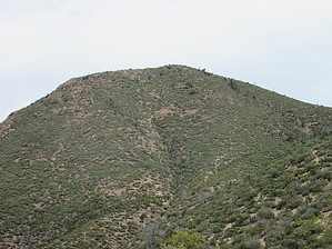
On Cloud Pine by DixieFlyer  Overview OverviewPine Butte is a somewhat obscure peak in the Mazatzal Mountains on the Maricopa County/Gila County line. Hike From the trailhead, you will see FR 201 going off to your left; FR 191 going off to your right; and an old jeep/OHV road in front of you that heads straight uphill. Take the jeep road, which is very rocky and very steep. You will gain 500 feet of elevation in about 0.4 miles.
Once at the first false summit, the hike is totally off-trail. The vegetation is mostly manzanita, chaparral, and wolfberry, although other assorted prickly bushes are not very friendly to humans. Fortunately, there is no catclaw, cholla, or cactus to deal with. Until you make the final ascent to the summit, the vegetation is not very dense. For the most part, you can walk around the vegetation rather than having to plow through it, which makes bushwhacking relatively easy. There are some ups and downs when going across the three false summits, but it is not very steep, and the bushwhacking continues to be relatively easy. However, in the last 0.2 miles to the summit, you'll gain about 325 feet in elevation, and the vegetation is a bit thick in places -- this is the most challenging part of the hike. Once atop the summit, you'll be able to enjoy some lovely 360-degree views of the Mazatzal Mountains and beyond. Factoid At an elevation of 6,420 feet above sea level, Pine Butte is the 10th highest peak in Maricopa County. Synopsis This hike is primarily of interest to peak baggers, but there are old mines and prospects in Pine Butte's vicinity that might be of interest to some hikers. Once back at the trailhead, some might wish to hike on FR 191 for a couple of miles or so to see the Mazzie Swingset. After hiking up to Pine Butte, peak baggers among us might also wish to drive to the Mount Peeley TH at the terminus of FR 201 and do the excellent Mount Peeley Summit hike. Check out the Official Route and Triplogs. Leave No Trace and +Add a Triplog after your hike to support this local community. | |||||||||||||||||||||||||||||||||||||||||||||||||||||||||||||||||||||||||||||||||||||||||||||||||||||||||||||||||||||||||||||||||||||||||||||||||||||||||||||||||||||||||||||||||||||||||||||||||||||||