Route Editor

| Guide | 0 Triplogs | 0 Topics |
details | drive | no permit | forecast | route |
stats |
photos | triplogs | topics | location |
| 39 | 0 | 0 |
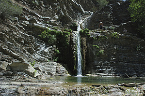
Paradise Lost by slegal  So why write a hike description for people that won't get the opportunity to hike it themselves? Because, when I say "Paradise Lost", I really mean it. If I can't take people out on this hike any longer, then I'll share what it was like when the land owner still tolerated the daily intrusions on his property.
Soon after the canyon starts heading north, the trail runs into lots of poison oak. In fact, at one point it is unavoidable, with a 10 foot high tangle of poison oak vines forming a tunnel that you must pass through to just to continue on. Bring Tecnu with you and you'll be fine. Soon after the poison oak tunnel there are little spur trails that will take you down to Matilija Creek. These are worthwhile side trips as the creek is quite beautiful in places. The creek is full of boulders all along its route. The canyon walls are quite tall and very steep and they occasionally let loose large boulders, many of which find their way into the creek. The canyon walls themselves are an interesting study in geology. The area is quite seismically active and the evidence of this can be easily recognized in the tilts and folds of layers of rock all along the canyon. Further along on the hike, the canyon walls close in on the canyon so tightly that frequent creek crossings are required in order to continue on. All along this section there are deep pools. In the spring time, before the pools are overgrown by algae, the water looks pristine and crystal clear. Eventually the canyon reaches an intersection with a small canyon off to the left. This is a must see side trip that treats you to a two tiered waterfall. If you climb up to the top of the bottom tier you reach a small pool that the top tier water fall drops into. It is a truly spectacular sight, particularly since it is in Southern California. Past this side canyon, Matilija Canyon continues for a short distance longer. The canyon reaches a spring that drops very cold water over a cliff through green moss and falls as gentle droplets to the ground. This is almost six miles in on the hike and this cold water is very refreshing. Just beyond the spring is a large, not quite vertical waterfall. There is a permanently placed rope along the side of the waterfall that facilitates climbing to the top. This is the turnaround point of the hike. The return trip is mostly downhill. Check out the Official Route. Leave No Trace and +Add a Triplog after your hike to support this local community. | |||||||||||||||||||||||||||||||||||||||||||||||||||||||||||||||||||||||||||||||||||||||||||||