username
X
password
register
for free!
help
 This is likely a great time to hike this trail!  Check out "Preferred" months below, keep in mind this is an estimate.
 

Cascade Falls Trail - Eldorado NF, CA

Guide 2 Triplogs  0 Topics
  3 of 5  
Fav
Wish
0
details
drive
no permit
forecast
route  
stats
photos
triplogs
topics
location
15 2 0
Statistics
tap row or icons for details
Difficulty 2 of 5
Route Finding 2 of 5
Distance Round Trip 2 miles
Trailhead Elevation 6,833 feet
Elevation Gain 736 feet
Avg Time Round Trip 3 hours
Kokopelli Seeds 5.68
 Interest Seasonal Waterfall & Seasonal Creek
 Backpack TBD
unreported if dogs are allowed
editedit > ops > dogs to adjust
feature photo
Photos Viewed All MineFollowing
Inaugural Calculation on Button Tap!
35  2017-05-31
Cascade Falls and South Maggie's Peak
OdinWiski
15  2009-08-17 slegal
Author
author avatar Guides 77
Routes 106
Photos 2,987
Trips 57 map ( 363 miles )
Age 63 Male Gender
Location Thousand Oaks, CA
Associated Areas
list map done
Sierra Nevada Region
Historical Weather
Trailhead Forecast
Radar Map
Expand Map
Preferred Jun, Sep, May, Oct → Early
Seasons   Late Spring to Early Autumn
Sun  5:32am - 6:26pm
Official Route
 
0 Alternative


 Likely In-Season!
The Cascade Falls Trail is a short hike near Emerald Bay in the Lake Tahoe area. The hike starts out of the Bayview Campground, which is across Highway 89 from the Emerald Bay viewpoint. Because of how busy this area is it is highly recommended that you get an early start or you may not be able to find a place to park. After you get a glimpse of Emerald Bay, you'll see why so many people want to see it. However, we're going hiking and that means walking away from the Emerald Bay viewpoint.


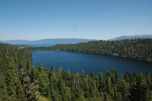
Since most people start the hike from somewhere near the Emerald Bay viewpoint, the hike technically starts at the entrance to the Bayview Campground and head to the back of the campground. The trailhead is well marked and starts up a small rise before descending along the side of a steep slope that drops straight into Cascade Lake. The trail soon levels out before heading back uphill toward the falls.
remove free decal offer
Once you reach the falls you'll want to leave the trail and head toward Cascade Creek. To get to the falls you'll need to do a little rock scrambling. You can get pretty close to the edge but as is always the case when near a drop off, use caution and good judgment. The actual falls are about 150 feet or so high, so their impressive. However, if you're looking for a vertical waterfall, then you've come to the wrong water fall. Cascade Falls is a very steep wall of granite, but it's not vertical. The water pretty much just slides down the walls rather than falls over it. Nevertheless, I like it.

After exploring the falls you may want to head back to the trail and continue on to the south. There is quite a bit of granite behind the falls and all of that granite makes for some pretty spectacular sights. We went back for a distance including some rock climbing until the kids started complaining.

The total distance to the falls is about 1 mile one way. Our trip log was 3.5 miles round trip which included lots of hiking around as the falls and a trip up to the granite mountains behind the falls.

2011-03-23 slegal


    Check out the Official Route and Triplogs.
    Leave No Trace and +Add a Triplog after your hike to support this local community.
    WARNING! Hiking and outdoor related sports can be dangerous. Be responsible and prepare for the trip. Study the area you are entering and plan accordingly. Dress for the current and unexpected weather changes. Take plenty of water. Never go alone. Make an itinerary with your plan(s), route(s), destination(s) and expected return time. Give your itinerary to trusted family and/or friends.

     Permit $$
    None


     Directions
    or
     Road
    Paved - Car Okay

    To hike
    From South Lake Tahoe Take South Lake Tahoe Blvd. (Highway 50) southwest to Highway 89 north. From South Lake Tahoe Blvd. The Emerald Bay parking lot is 7.6 miles. The parking lot is on the right side of the road and the Bayview Campground is on the left.
    page created by slegal on Mar 23 2011 6:01 pm
     90+° 8am - 6pm kills
    helpcorrectionissue

    end of page marker