Route Editor

| Guide | 0 Triplogs | 0 Topics |
details | drive | permit | forecast | route |
stats |
photos | triplogs | topics | location |
| 8 | 0 | 0 |
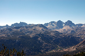
To the west is Devil's Postpile, the Minarets, Mount Ritter and Mount Banner. To the south are incredible views of Mammoth Mountain, Pyramid Peak, Laurel Mountain and Bloody Mountain. To the east are views of the Obsidian Domes and Bald Mountain. To the north is June Mountain.
Knowing about the proposal makes it interesting to look over the eastern edge of the ridge and see the terrain that could have been where a lift or a ski trail might have been. One conclusion I came to is that the eastern and southeastern exposure of much to the terrain would get baked pretty quickly after a storm. Consequently, the snow would not be considered that good compared to the snow on the north facing slopes of Mammoth Mountain and June Mountain. Nevertheless, I find it interesting to contemplate what could have been. The trail is strictly an out and back. There are no loops to connect with up here. It is worthwhile going all the way to the end of the trail as it is the highest point on the trail and offers the best views. Check out the Official Route. Leave No Trace and +Add a Triplog after your hike to support this local community. | |||||||||||||||||||||||||||||||||||||||||||||||||||||||||||||||||||||||||||||||||||||||||