 Route Editor

| Guide | ♦ | 1 Triplog | 0 Topics |
details | drive | permit | forecast | 🔥 route |
stats |
photos | triplog | topics | location |
| 49 | 1 | 0 |
Unless you arrive at the ranger station at Minaret Summit before 7:00AM or you have a campsite beyond the ranger station, you will have to turn around and drive back to Mammoth Mountain's main lodge and buy a ticket on the Devils Postpile bus. It's worthwhile taking the bus. You don't have to concentrate on the road and can look at the scenery instead.
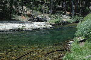
The PCT heads up over a ridge and heads steeply down into the canyon that the middle fork of the San Joaquin River passes through. This section of the trail is rugged with a raw beauty to it. You're never too far from the San Joaquin River which in many places is raging below. All along the way you pass various small creeks heading down steeply toward the river below. As you near Soda Springs the trail intersects with a couple of trails that head off to the left toward the Soda Springs Campground. Stay to the right and head across the bridge over the San Joaquin River. About 1.4 miles after the river crossing, the trail reaches Minaret Falls. Depending on how much snow feel the previous winter and when you visit Minaret Falls, the falls can be absolutely raging or just a trickle. Shortly after the trail passes Minaret Falls the trail merges with the John Muir Trail. The remainder of this hike description is with the two trails merged. A half mile after the merger, the trail crosses the San Joaquin River again. This crossing takes you straight to the Devils Postpile. The Postpile is a volcanic lava flow that laid down a layer of basalt that cooled to form basalt columns. After word the tops of the columns were sheared off and smoothed by glaciation. Form the PCT the view is of the massive columns below. There is a short loop trail that begins and ends on the PCT that will take you to the top of the Postpile. On top of the Postpile the columns fit tightly together giving the look of interlocking pavers. The southern terminus of the Postpile loop marks the eastern boundary Devils Postpile National Monument, which is technically the end of this hike description. A quarter mile past the loop trail terminus is a trail that will take you to the Red's Meadow Campground. There you can catch a bus back to Mammoth Mountain. Some inside advice: If it is late in the afternoon, the bus will be full. Instead, get on the bus heading down to the Red's Meadow Pack Station. If you still have energy when you get to the trail to Red's Meadow Campground, you may want to continue on to Rainbow Falls. It is a worthwhile trip. Check out the Official Route and Triplog. Leave No Trace and +Add a Triplog after your hike to support this local community. One-Way Notice This hike is listed as One-Way. When hiking several trails on a single "hike", log it with a generic name that describes the hike. Then link the trails traveled, check out the example. | |||||||||||||||||||||||||||||||||||||||||||||||||||||||||||||||||||||||||||||||||||||||||||||||||||||||


